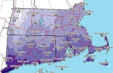
COURTESY OF MEMA: Expected wind chill values Thursday night into Friday morning.
HYANNIS – Winter does not officially start until next week but low temperatures and high winds will make it feel like it is already here tonight and Friday.
The National Weather Service has issued a High Wind Warning for the region from 5 p.m. through 5 a.m. with sustained winds up to 30 mph and potential 70 mph gusts.
High winds combined with overnight lows under 10 degrees could see wind chills hit 10 to 20 below zero which National Weather Meteorologist Bill Sampson says can be harmful.
“If you have to be out any prolonged time have something on the face because those kinds of wind gusts can take away the surface heat of your skin pretty rapidly and you can get frostbite in about 10 minutes or so,” Sampson said.
High temperatures on Friday are expected to be around 20 degrees on Cape Cod with a chance of snow falling during the evening and through the overnight hours.
“The one good thing is this is a relatively short event,” Sampson said.
Snow is expected to turn to rain on Saturday as temperatures rise to about 50 degrees. Highs on Cape Cod could reach 60 degrees on Sunday.
When it comes to tonight and Friday, Sampson said to “bundle up.”