 BARNSTABLE – A new planning tool called FRED and new thresholds for business are among the initiatives announced by the Cape Cod Commission this week.
For years, 10,000 square feet has been the threshold for building on Cape Cod. Beyond that, projects need approval from the Cape Cod Commission.
That has resulted in a lot of buildings at 9,900 square feet, Cape Cod Commission Executive Director Paul Niedzwiecki said.
To address that problem, the Commission sought authority to increase thresholds for Developments of Regional Impact (DRIs) to exceed the threshold in areas where it made sense. The new threshold is 40,000 square feet.
In 2009, a section in the Commission’s code of regulations, Chapter H, was created to allow towns the opportunity to raise or lower DRI thresholds within their borders. But since Chapter H was created, no towns applied for the new designation. That is why Niedzwiecki said, the Commission sought the authority to grant the designation itself.
The Assembly of Delegates granted permission last fall for the Commission to approve such districts.
With that authority, the Commission on May 8 approved increased building thresholds in four industrially-zoned areas in the Upper Cape.
The areas are Falmouth Technology Park and Edgerton Drive in Falmouth, Jonathan Bourne Drive in Bourne and Sandwich Industrial Park in Sandwich.
Since the approval, several other towns have expressed interest in developing areas for the special designation to allow the larger buildings, according to Niedzwiecki said.
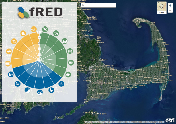
As for FRED, it is a new web-based tool that uses GPS to help towns plan for increased development. It helps towns identify the best locations for new development, re-development and other economic development by looking at a number of criteria like workforce and water protection.
With just 13 percent of commercially-zoned parcels on Cape Cod vacant, the need for smarter re-development planning is critical, Niedzwiecki said.
. THE TOOL USES GPS MAPPING TO SHOW TOWNS THE DEVELOPMENT POTENTIAL OF PARCELS.