


Potential storm track late Sunday night into Monday
(HYANNIS) – Cape Cod and the Islands are bracing for another possible winter blast late Sunday night into Monday, with the possibly of a Nor’easter just off the coast of Massachusetts.
The National Weather Service has issued a winter storm watch, high wind watch, and coastal flood watch for the area from Sunday night through Monday evening – with the possibility of more than six inches of snow, combined with winds that could gust to near 60 mph.
Forecasters also said there is the possibility of coastal flooding related to the storm and already astronomically high tides.
This would be the latest in a string of winter storms that have brought significant snows to New England during the winter of 2026.
The National Weather Service said peak snowfall rates could happen later Sunday night into Monday before snow tapers off on Monday night. There is also increasing confidence in seeing widespread 50 to 60 mph gusts on Cape Cod and the Islands and most of the coastal waters.
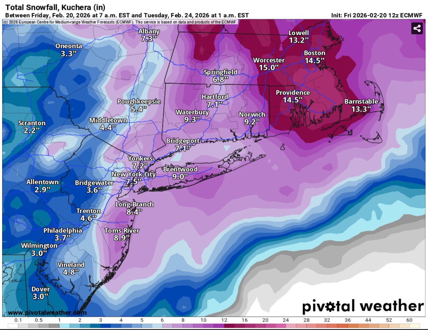
Potential snow accumulation
High astronomical tides Monday into Tuesday also brings the potential for minor to moderate coastal flooding along the eastern coast, depending on the timing of the highest surge.
Continue to check with Cape Wide News before, during and after the storm.
Here are the official watches from the National Weather Service:
…WINTER STORM WATCH IN EFFECT FROM LATE SUNDAY NIGHT THROUGH
MONDAY EVENING…
* WHAT…Heavy snow possible. Total snow accumulations of more than
6 inches possible.
* WHERE…South coastal Massachusetts and Rhode Island, including
Cape Cod and the Islands.
* WHEN…From late Sunday night through Monday evening.
* IMPACTS…Whiteout conditions are possible at times and may make
travel treacherous and potentially life-threatening.
…HIGH WIND WATCH IN EFFECT FROM MONDAY MORNING THROUGH MONDAY EVENING…
* WHAT…Northeast winds 25 to 35 mph with gusts up to 60 mph possible.
* WHERE…Cape Cod, Marthas Vineyard, Nantucket, and Block Island.
* WHEN…From Monday morning through Monday evening.
* IMPACTS…Damaging winds could bring down trees and power lines.
Power outages are possible. Travel could be difficult, especially
for high profile vehicles.

Potential winds during storm
…COASTAL FLOOD WATCH IN EFFECT FROM MONDAY EVENING THROUGH
* WHAT…Minor to moderate coastal flooding possible. Flooding could be as deep as 1 to 3 feet.
* WHERE…Eastern Massachusetts coast, including Cape Cod and the Islands.
* WHEN…From Monday evening through Tuesday morning.
* IMPACTS…Numerous roads may be closed around high tides early Monday morning and again early Tuesday morning. Debris may wash onto coastal roads from wave action. Low lying property including homes, businesses, and some critical infrastructure may be inundated. Significant beach erosion is likely.


