CAPE COD – Officials across Cape Cod are preparing for a dangerous nor’easter that will begin impacting the region Friday. Forecaster’s are warning of the potential for hurricane force wind gusts as well as major coastal flooding. While severe erosion is anticipated along outer Cape ocean beaches, the most vulnerable areas for flooding are from the Cape Cod Canal to Rock Harbor in Cape Cod Bay. The far west end of Provincetown which was hit hard in the January “bomb cyclone” could also have significant flooding as well. Listen to your local authorities and heed any evacuation orders that may be issued. Cape Wide News will have full coverage of the storm. We’ll post statements from local agencies here so check back frequently.
Brewster:
With the latest storm underway here are some of things we should be paying attention to:
FLOODING: With a similar storm pattern in January, we saw Rt. 6A closed for approximately 3 hrs surrounding high tide in the area of Lower Road, Paines Creek, and the Brewster/Dennis line. If you see standing water in these areas, DO NOT DRIVE THROUGH IT. The next 3 high tide cycles are of concern. They are 11:17 am, 11:47 pm, and 12:07 pm tomorrow. Roads could flood up to an hour prior to high tide and stay flooded well past high tide.
WINDS: Sustained winds in the 25-40 mph range with gusts as high as 75-80 are expected. It looks like the highest winds are projected for this afternoon and tonight, but high wind will linger into tomorrow. We are anticipating tree limbs coming down, which could result in power outages. DO NOT CALL 911 FOR POWER OUTAGES. To report a power outage, contact Eversource at 800-286-2000 or via their website.
RAIN: We are early into this storm and already seeing ponding in the normal spots around town. With the amount of rain in the forecast, it is likely those puddles will continue to grow and we may see puddles in areas that we do not normally. Please use caution while driving.
Barnstable:
Statement from Barsntable Fire “The most vulnerable areas in Barnstable Village for coastal flooding are in the Millay, Commerce Road, Rendezvous Lane, and Keveny Lane areas. Other areas near the coast may be affected depending on the amount of storm surge. Residents in these areas should be prepared for possible flooding activity and consider early evacuation. There is a significant concern for mariners with this storm, and it is strongly recommended that small watercraft are removed from the water and mariners refrain from any activity on the water until after the storm passes. The Barnstable Fire Department is ramping up our on-duty staffing, we have pre-staged our high water vehicle assets for the duration of the storm, and we are prepared to respond to any emergencies that we are presented with.”
Sandwich:
Warning: there will be a high impact storm event on Friday and Saturday that will include strong winds, rain, and coastal storm surges. There is a high risk of flooding. Please do not try to pass through flooded areas. Stay away from coastal areas including the Sandwich marina, Boardwalk and Town Neck Beach. Please avoid the following roads during high tides: Route 6A, Jarves Street, Dewey Ave, Wood Ave Ext, and Jones Lane. Residents in homes that have a history of flooding in the past should consider leaving the area ahead of time. Thank you for your cooperation.
Dennis:
Dennis Police urge people to please use caution when driving if you must be on the roadway. Stay away from large puddles and areas that are known to flood.
Citizens encountering fallen trees or wires should call the Police Department using the 911 system – if an emergency – or dialing 508-394-1313. Do not go near downed lines – they may be charged. Police or fire personnel will respond to these calls and notify appropriate utilities.
Contact Eversource (Electric Company) to report any power outages at 1-800-592-2000. Citizens are encouraged to use the Eversource phone system to report power outages – the system automatically tracks these calls and provides information to Eversource as to how many people are out in a given area. The system will also give the caller a call back to provide information as to when the power is expected to be turned back on.
Use 911 for emergencies only, for all other calls you can dial 508-394-1313.
Eastham:
Please be advised as of sundown Thursday, Nauset Marsh, Town Cove and Cape Cod Bay in the town of Eastham will be closed to shellfishing until further notice. The State has closed all shell fishing areas in the commonwealth at sundown Thursday until further notice.
Chatham:
Effective 10:00 am Friday, Nauset Beach South OSV Trails will be closed until further notice due to expected storm surge, high winds and tide conditions. Conditions will be assessed daily and updates provided.
Chatham Emergency Management is urging residents on Morris Island, Stage Island, Eastward Point and other low-lying areas susceptible to flooding to continue to be vigilant in monitoring the impending storm.
Residents in these areas may be without power for extended periods of time, and RESCUE FROM THESE AREAS DURING THE STORM AND FOR SOME TIME AFTERWARDS WILL NOT BE POSSIBLE.
Chatham Emergency Management recommends that residents LEAVE THESE MENTIONED AREAS BEFORE THE STORM.
Be sure to take essential items – medicine, special food, personal items, baby supplies, pets, clothing, money and valuable papers, but do not overload your vehicle.
Return to these areas may be restricted based on weather conditions and public safety.
Please secure your homes before you leave. Please check on any neighbors who may need assistance.
If you have questions, please contact:
Chatham Fire Department – 508-945-2324
Chatham Emergency Management – [email protected]
Chatham Police Department – 508-945-1213
A message from the town of Chatham. Town officials would like to notify you of the impending nor’easter that is due to affect the area Friday morning thru saturday evening. Due to the astronomical high tides, flooding in low lying areas is expected. Flooding could be similar to the storm we experienced on January 4th. Officials are recommending that people living in these low lying areas evacuate for the duration of the storm. Roads in these areas may be impassable. Power could be out for as long as 72 hours and rescue from these areas during the storm and for some time afterwards may not be possible. Please take precautions.
Provincetown:
Provincetown Police report that sandbags can be used at entry points to prevent or reduce flooding. While sandbags won’t fully insulate your property from the impact of flooding, they could greatly minimize the damage that flood water can cause and help save you money on clean-up and repair work
1,500 sandbags will be available to those in need. They will be available Thursday at the DPW highway garage (off Race Point Road) from 7 am to 4 pm. These bags need to be self-filled by the recipient. These should be filled to around two-thirds full and only sand should be used, not soil or hay bales.
A small group of AmeriCorps volunteers may be available Thursday until 2 pm to assist you with filling and loading.
Police also report that it is anticipated that an emergency parking ban will go into effect onto Commercial Street Thursday which will remain in effect until sometime over the weekend. Residents should consider using free off-street parking and moving your vehicle into one of the town owned parking lots this morning.
On the subject of parking. Police suggest using the Grace Hall lot and not leaving your vehicle in the Johnson, West End or MPL parking lots.
Barnstable County Regional Emergency Planning Committee:
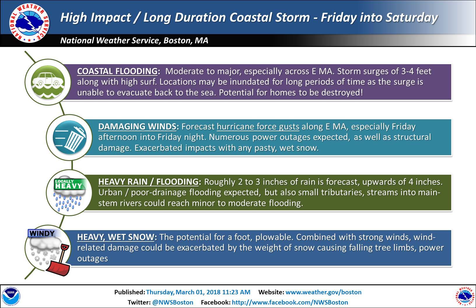
The Barnstable County Regional Emergency Planning Committee (BCREPC) held a conference call at 10 a.m. March 1, 2018, to discuss preparations for the approaching ocean storm.
The BCREPC meteorologist reported that winds will increase on Friday morning with the greatest threat in the Cape/Islands area where damaging hurricane force wind gusts of 75 – 80 mph may occur. This will last from near 10 a.m. Friday to 10 am Saturday. Numerous power outages are likely. Citizens should be prepared for power outages with emergency supplies sufficient for 3 days.
Major coastal flood and surge threat exists for several tide cycles starting with the Friday late-morning tide going through the late-morning Saturday tide. This could extend to the Saturday evening tide if the system is slow to move out. Surge values over 3.5 feet on top of an already astronomically high March tide, will cause potentially major flooding.
Heavy rainfall will overspread the region on Friday morning with 3-inch amounts and isolated 4-inch amounts possible over a 24-hour period.
Electric utility Eversource will prestage tree, pole, and line crews on the Cape ahead of the storm.
The BCREPC Multi-Agency Coordination Center (MACC) operated by the Barnstable County All Hazards Incident Management Team will be activated at 6 a.m. Friday.
No Regional Emergency Shelter System activation is planned at this time, but the Shelter System plan is in place and ready for activation if necessary.
United State Coast Guard:
The Coast Guard is advising mariners and the public along the Massachusetts and Rhode Island coast to exercise vigilance and extreme caution Thursday night through Saturday as a powerful storm approaches.
Conditions are expected to deteriorate Thursday night. Along with heavy rain and strong wind gusts, high tide cycles from Friday into Saturday are at risk for widespread, major coastal flooding. The intensity and height of the predicted storm’s wave action combined with the astronomically high tides, and the long duration of this coastal storm, could significantly exceed the coastal flooding damage experienced during the Nor’easter this past January.
The forecasted high winds, rain, coastal flooding, and heavy seas will make operation in the maritime environment dangerous.
Coast Guard Air Station Cape Cod aircraft have been flying storm tracks ahead of the storm to warn mariners of the impending storm. Click here for audio of the broadcast.
Coast Guard Cutter Spencer, a 270-foot cutter homeported in Boston, will be staged off the coast to respond to offshore search and rescue cases.
Due to the extreme conditions some Coast Guard assets may have limited ability to respond to vessels in distress. Therefore, waterfront operators, mariners, fishing vessels, recreational boaters, and the general public should exercise extreme caution as conditions begin to deteriorate on Thursday night.
Mariners and recreational boaters are warned to take the following precautions to protect their vessels and their crews:
- If a storm is approaching, do not go out to sea.
- Double-check lines when securing your boat. Take precautions for items stored loosely aboard.
- Please secure all paddle craft and ensure they are not located in or near the tidal surge zone.
- Contact local marinas for advice on how best to secure your vessel.
- If you must get underway, create a float plan and send it to your friends and families before getting underway. Ensure that you have the proper signaling devices onboard your vessel and the correct amount of life jackets onboard.
- The storm is likely to produce dangerous winds and coastal flash flooding. Personal watercraft and paddle craft users are advised to stay off the water due extremely hazardous sea conditions. Also, swimmers, surfers, and wind surfers are strongly urged to stay out of the water during this period of heavy weather.
- Always wear a proper life jacket when on a boat or personal watercraft.
All boaters and those living along coastal communities are urged to secure their small craft, including canoes, kayaks, and paddle craft, due to the expected high winds, heavy seas, and storm surge. Paddle craft owners are urged to pull and secure vessels well above high water levels to avoid craft being pulled off the shore. Once at sea, unmanned craft often result in complex, unnecessary searches thereby reducing Coast Guard’s capability to respond to actual distress at sea. Also, please clearly mark all paddle craft with owner’s name and contact information.
Coast Guard Sector Boston’s area of responsibility extends from Plymouth, MA, to the Massachusetts/New Hampshire border and is expected to be heavily impacted.
“Our primary concern is ensuring the safety of the people and mariners who live and work throughout the New England coastal community,” said Capt. Claudia Gelzer, Commander, Coast Guard Sector Boston. “We strongly advise everyone to stay vigilant, pay attention to any weather updates, and avoid putting themselves or their loved ones at risk as the storm passes off the coast.”