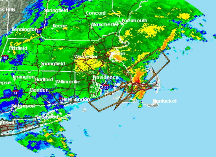
HYANNIS – A strong line of thunderstorms rolled across Cape Cod Monday night prompting the National Weather Service to issue a Tornado Warning for Barnstable County.
The storm moved onto Cape Cod shortly after 9:30 p.m. with strong winds and heavy rain.
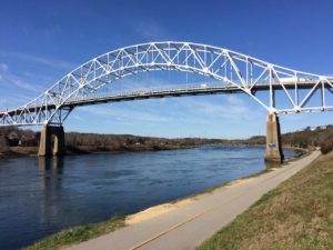
There were reports of significant flooding at the base of the Sagamore Bridge and a lighting strike in Sandwich on Viking Lane.
Mutual aid from several surrounding towns responded to the reported fire that resulted from the lightning strike.
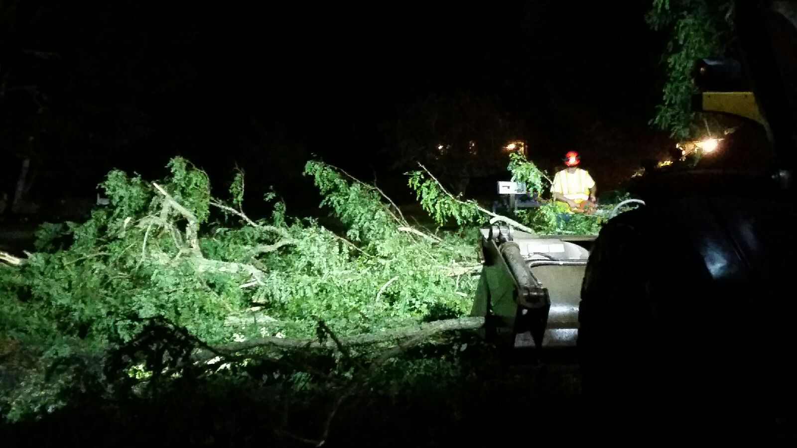
Harwich DPW works to clear trees from Williams Way.
Harwich Police responded to reports of a tree down on a house on Pleasant Lake Avenue (Route 124). The department posted that they have large limbs and tree damage in parts of town with wires down. Please If you don’t need to be on the roads stay off until highway department can clean up the roads and Eversource can make repairs.
Skywarn reported a large limb down on Route 28 in the area of 274 Route 28 in Harwich just after 10:30 p.m, a 52 mph wind gust in Dennis, a tree down on Great Neck Road South in Mashpee and on Asa Meigs Road in Marstons Mills.
Eversource reported scattered outages including about 400 in Falmouth, and 250 in Wellfleet.
We have @kb1qcq looking at the damage in hHarwich, MA. Here are the first damage photos out of Main Street in Harwich, Mass. Very difficult to do at night but Tom-KB1QCQ is making a great effort! See first set of pictures. #mawx pic.twitter.com/CzXQRpZDIx
— NWS Boston/Norton Skywarn (@WX1BOX) July 23, 2019
The following was the original warning issued by the National Weather Service:
Tornado Warning
Tornado Warning
BULLETIN – EAS ACTIVATION REQUESTED
Tornado Warning
National Weather Service Boston/Norton MA
955 PM EDT Mon Jul 22 2019
The National Weather Service in Boston/Norton has issued a
* Tornado Warning for…
Southwestern Barnstable County in southeastern Massachusetts…
* Until 1045 PM EDT.
* At 954 PM EDT, a severe thunderstorm capable of producing a tornado was located near Mashpee, or near Falmouth, moving northeast at 30 mph.
HAZARD…Tornado.
SOURCE…Radar indicated rotation.
IMPACT…Flying debris will be dangerous to those caught without shelter. Mobile homes will be damaged or destroyed. Damage to roofs, windows, and vehicles will occur. Tree damage is likely.
* This dangerous storm will be near…
Mashpee around 1010 PM EDT.
Barnstable and Yarmouth around 1025 PM EDT.
Dennis around 1030 PM EDT.
Other locations impacted by this tornadic thunderstorm include Hyannis.
PRECAUTIONARY/PREPAREDNESS ACTIONS…
TAKE COVER NOW! Move to a basement or an interior room on the lowest floor of a sturdy building. Avoid windows. If you are outdoors, in a mobile home, or in a vehicle, move to the closest substantial shelter and protect yourself from flying debris.
Torrential rainfall is occurring with this storm, and may lead to flash flooding. Do not drive your vehicle through flooded roadways.
TORNADO…RADAR INDICATED
HAIL…<.75IN
BULLETIN – EAS ACTIVATION REQUESTED
Tornado Warning
National Weather Service Boston/Norton MA
1021 PM EDT Mon Jul 22 2019
The National Weather Service in Boston/Norton has issued a
* Tornado Warning for…
East central Barnstable County in southeastern Massachusetts…
* Until 1100 PM EDT.
* At 1021 PM EDT, a severe thunderstorm capable of producing a
tornado was located over Harwich, or near Brewster, moving
northeast at 40 mph.
HAZARD…Tornado.
SOURCE…Radar indicated rotation.
IMPACT…Flying debris will be dangerous to those caught without
shelter. Mobile homes will be damaged or destroyed.
Damage to roofs, windows, and vehicles will occur. Tree
damage is likely.
* This dangerous storm will be near…
Orleans and Eastham around 1030 PM EDT.
PRECAUTIONARY/PREPAREDNESS ACTIONS…
TAKE COVER NOW! Move to a basement or an interior room on the lowest
floor of a sturdy building. Avoid windows. If you are outdoors, in a
mobile home, or in a vehicle, move to the closest substantial shelter
and protect yourself from flying debris.
_______
NWS damage reports:
0950 PM     MARINE TSTM WIND WOODS HOLE              41.53N  70.67W
07/22/2019  M42 MPH          BARNSTABLE         MA   AMATEUR RADIO

0955 PM     MARINE TSTM WIND BARLOWS LANDING         41.69N  70.63W
07/22/2019  M43 MPH          BARNSTABLE         MA   AMATEUR RADIO

            REPORT FROM MARINE VESSEL LANGDON

0955 PM     MARINE TSTM WIND WAQUOIT BAY             41.55N  70.55W
07/22/2019  M53 MPH          BARNSTABLE         MA   MARINE MESONET

1005 PM     LIGHTNING        SANDWICH                41.76N  70.50W
07/22/2019                   BARNSTABLE         MA   AMATEUR RADIO

            HOUSE FIRE DUE TO LIGHTNING ON VIKING LANE

1012 PM     FLOOD            SAGAMORE                41.77N  70.53W
07/22/2019                   BARNSTABLE         MA   AMATEUR RADIO

            CAR STUCK IN FLOOD WATERS AT THE BASE OF THE SAGAMORE
            BRIDGE.

1013 PM     TSTM WND DMG     MASHPEE                 41.65N  70.48W
07/22/2019                   BARNSTABLE         MA   AMATEUR RADIO

            TREE DOWN ON GREAT NECK ROAD SOUTH

1013 PM     TSTM WND DMG     BARNSTABLE              41.70N  70.30W
07/22/2019                   BARNSTABLE         MA   AMATEUR RADIO

            TREE DOWN ON ASA MEIGS ROAD IN MARSTONS MILLS. OAK
            STREET WITH TREE DOWN BLOCKING ONE LANE OF THE ROAD IN
            WEST BARNSTABLE.

1018 PM     MARINE TSTM WIND WEST DENNIS             41.65N  70.17W
07/22/2019  M51 MPH          BARNSTABLE         MA   MESONET

1020 PM     TSTM WND DMG     HARWICH                 41.69N  70.07W
07/22/2019                   BARNSTABLE         MA   AMATEUR RADIO

            2 LARGE TREES DOWN ON A HOUSE ON PLEASANT LAKE AVENUE -
            ROUTE 124. 2 LARGE TREES DOWN BLOCKING ONE LANE OF ROUTE
            124. TREE DOWN ON BANK STREET. TREE DOWN ON GOTHAM ROAD.
            TREE DOWN ON SISSON ROAD. LARGE LIMB DOWN BLOCKING ROUTE
            28 IN THE AREA OF 274 ROUTE 28. LARGE TREE AND WIRES
            DOWN ON GUILFORD DRIVE. TREE AND WIRES DOWN ON MAIN
            STREET AT UNCLE HARRYS ROAD.

1024 PM     MARINE TSTM WIND CHAPIN                  41.73N  70.23W
07/22/2019  M43 MPH          BARNSTABLE         MA   MESONET