![]()
Tropical Storm Warning
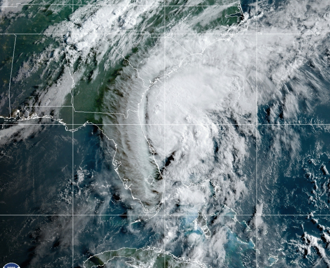
Isaias Local Watch/Warning Statement/Advisory Number 26
National Weather Service Boston/Norton MA AL092020
1111 AM EDT Mon Aug 3 2020
…TROPICAL STORM WARNING IN EFFECT…
A Tropical Storm Warning means tropical storm-force winds are expected somewhere within this area within the next 36 hours
* LOCATIONS AFFECTED
– Chatham
– Falmouth
– Provincetown
* WIND
– LATEST LOCAL FORECAST: Tropical storm force winds remain possible
– Peak Wind Forecast: 20-30 mph with gusts to 40 mph
– THREAT TO LIFE AND PROPERTY THAT INCLUDES TYPICAL FORECAST UNCERTAINTY IN TRACK, SIZE AND INTENSITY: Potential for wind 39 to 57 mph
– The wind threat has remained nearly steady from the previous assessment.
– PLAN: Plan for hazardous wind of equivalent tropical storm force.
– PREPARE: Efforts to protect property should now be underway. Prepare for limited wind damage.
– ACT: Act now to complete preparations before the wind becomes hazardous.
– POTENTIAL IMPACTS: Limited
– Damage to porches, awnings, carports, sheds, and unanchored mobile homes. Unsecured lightweight objects blown about.
– Many large tree limbs broken off. A few trees snapped or uprooted, but with greater numbers in places where trees are shallow rooted. Some fences and roadway signs blown over.
– A few roads impassable from debris, particularly within urban or heavily wooded places. Hazardous driving conditions on bridges and other elevated roadways.
– Scattered power and communications outages.
* STORM SURGE
– No storm surge inundation forecast
– THREAT TO LIFE AND PROPERTY THAT INCLUDES TYPICAL FORECAST UNCERTAINTY IN TRACK, SIZE AND INTENSITY: Little to no storm surge flooding
– The storm surge threat has remained nearly steady from the previous assessment.
– PLAN: There is little to no threat of storm surge flooding. Rough surf, coastal erosion, and life-threatening rip currents are possible.
– PREPARE: Little to no preparations for storm surge flooding are needed.
– ACT: Follow the instructions of local officials. Monitor forecasts.
– POTENTIAL IMPACTS: Little to None
– Little to no potential impacts from storm surge flooding.
* FLOODING RAIN
– LATEST LOCAL FORECAST:
– Peak Rainfall Amounts: around 1 inch
– THREAT TO LIFE AND PROPERTY THAT INCLUDES TYPICAL FORECAST UNCERTAINTY IN TRACK, SIZE AND INTENSITY: Potential for localized flooding rain
– The flooding rain threat has remained nearly steady from the previous assessment.
– PLAN: Emergency plans should include the potential for localized flooding from heavy rain.
– PREPARE: Consider protective actions if you are in an area vulnerable to flooding.
– ACT: Heed any flood watches and warnings.
– POTENTIAL IMPACTS: Limited
– Localized rainfall flooding may prompt a few evacuations.
– Rivers and tributaries may quickly rise with swifter currents. Small streams, creeks, and ditches may become swollen and overflow in spots.
– Flood waters can enter a few structures, especially in usually vulnerable spots. A few places where rapid ponding of water occurs at underpasses, low-lying spots, and poor drainage areas. Several storm drains and retention ponds become near-full and begin to overflow. Some brief road and bridge closures.
* TORNADO
– LATEST LOCAL FORECAST:
– Situation is unfavorable for tornadoes
– THREAT TO LIFE AND PROPERTY THAT INCLUDES TYPICAL FORECAST UNCERTAINTY IN TRACK, SIZE AND INTENSITY: Tornadoes not expected
– The tornado threat has remained nearly steady from the previous assessment.
– PLAN: Tornadoes are not expected. Showers and thunderstorms with gusty winds may still occur.
– PREPARE: Little to no preparations needed to protect against tornadoes at this time. Keep informed of the latest tornado situation.
– ACT: Listen for changes in the forecast.
– POTENTIAL IMPACTS: Little to None
– Little to no potential impacts from tornadoes.
* FOR MORE INFORMATION:
– https://www.weather.gov/box