


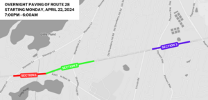
Tropical Storm Watch in Effect
Today: A slight chance of showers after 2pm. Partly sunny, with a high near 73. Breezy, with a northeast wind 16 to 24 mph. Chance of precipitation is 20%.
Tonight: Tropical storm conditions possible. Showers likely, mainly after 1am. Patchy fog after 1am. Otherwise, cloudy, with a low around 65. Northeast wind 25 to 30 mph, with gusts as high as 45 mph. Chance of precipitation is 60%. New precipitation amounts between a tenth and quarter of an inch possible.
Labor Day: Showers likely and possibly a thunderstorm. Some of the storms could produce heavy rain. Patchy fog before noon. Otherwise, cloudy, with a high near 74. Windy, with a northeast wind 20 to 28 mph, with gusts as high as 45 mph. Chance of precipitation is 60%. New rainfall amounts between a quarter and half of an inch possible.
Monday Night: Tropical storm conditions possible. A chance of showers and thunderstorms, then showers likely and possibly a thunderstorm after midnight. Some of the storms could produce heavy rain. Patchy fog before 2am, then patchy fog after 3am. Otherwise, cloudy, with a low around 68. East wind 10 to 15 mph. Chance of precipitation is 60%. New rainfall amounts between a quarter and half of an inch possible.
Tuesday: Tropical storm conditions possible. Showers likely and possibly a thunderstorm. Some of the storms could produce heavy rain. Patchy fog before noon. Otherwise, cloudy, with a high near 76. Chance of precipitation is 70%.


Speak Your Mind