


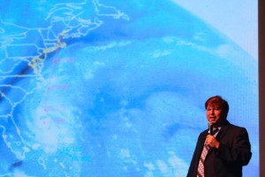
CCB MEDIA PHOTO
Glenn Field, Warning Coordination Meteorologist with the National Weather Service in Taunton, speaks about similarities among hurricanes that have hit New England.
WEST BARNSTABLE – Hurricanes that hit New England have several things in common, according to Glenn Field, Warning Coordination Meteorologist with the National Weather Service in Taunton.
They begin as named storms in the Caribbean and they track along the coast, arriving off North Carolina by the fourth day. At that point, New Englanders need to be prepared for a direct hit, Field said, even though it has been 61 years since Hurricane Carol hit the region as a Category 3 storm.
A small but attentive crowd gathered last night at Cape Cod Community College and listened as Field and other emergency management officials gave tips on what to look for and how to be prepared for the next big storm, which, he said, is overdue to hit the region, according to statistics gathered about storms that have impacted New England over the past 100 years.
“The rule of thumb for emergency managers is anything with a name in the Bahamas is when you start preparations, not when it gets to North Carolina. That’s when you have to be finished,” Field said.
He showed a study of storms that have impacted New England over the last century and where they started to reveal the patterns.
Hurricane Bob hit southern New England as a weak Category 2 storm in 1991, but when it comes to strong storms, Field said, besides Hurricane Carol, there is the Hurricane of 1938 that hit the region with ferocious power.
“Anything with a name in the Bahamas is the point at which southern New England has to take action. The empirical rule of thumb is it has to get west of 72 west to have a chance of really getting us,” Field said, referring to the latitude similarities of storms that have tracked toward New England.
Field said there is also important information gained by studying the results of storms that have hit the region and the key element there is where the eye of the storm lands.
“The second rule of thumb is you do need to know where you are with respect to the track of the eye. Because northwest of the track, that’s where the flooding rings are. Southeast of the track, that’s where the strong winds and the storm surge are.
Because of the length of time that have passed since the last major hurricane hit the region, being prepared is key and toward that end, the state has put together a range of written materials as well as websites and apps to help people get ready for the next storm.
Many tips can be found at the website www.mass.gov/MEMA/ready.


Speak Your Mind