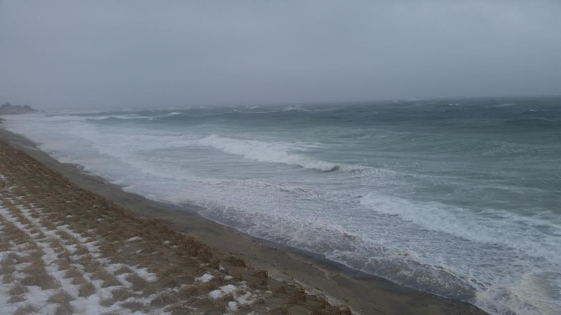
Town Neck Beach in Sandwich at high tide Tuesday
HYANNIS – A mid-March Nor’easter is hitting the Cape and Islands with strong winds, snow and rain today.
The National Weather Service issued a winter weather advisory for the region, which was a downgrade from a winter storm watch which had initially been posted.
Snowfall totals on Cape Cod and Martha’s Vineyard are expected to range from 2 to 4 inches, with just 1 inch on Nantucket.
A coastal storm watch and high wind watch remain in effect for the region as two low pressure systems converge off the mid-Atlantic.
Winter storm warnings are in effect for the Boston area and blizzard warnings for the greater Worcester area, where 2-feet of snow is possible.
Winds will blow out of the east at 30 to 40 miles an hour, with some gusts as high at 75 miles an hour.
The strongest winds will be from Tuesday morning into Tuesday afternoon. By mid-afternoon,
The Barnstable County Regional Emergency Planning Committee activated the Multi-Agency Coordination Center, a tool that allows towns to request resources from the county and state during the storm.
Officials said they’re ready to respond to any issues that may arise.
Public Information Officer Kevin Morley said the shelter system won’t be activated at this time, but remains on standby.
Morley said officials will be monitoring any coastal impacts. A 2 to 3 foot storm surge could be possible around high tide.
Eastern facing beaches face the biggest risk during the early Tuesday afternoon tide. Widespread minor flooding is possible with pockets of moderate coastal flooding. Some overwash is also possible along the ocean-exposed shoreline.
Eversource, which provides electricity to Cape Cod and Martha’s Vineyard said they were ready to address any storm-related power outages. The company is preparing for the possibility of tree-related damage to its electric system and will have crews and support staff ready to respond.
Crews were responding to multiple power outages across Cape Cod, as trees and limbs came down on power lines. Local police departments were being kept busy by trees that fell onto roadways.
Customers are encouraged to also prepare for the possibility of outages.
“We design and build our system to stand up to the effects of storms like this and our staff will be ready to address any damage the snow and winds might cause,” said Mike Hayhurst, Vice President of Electric System Operations at Eversource.
“We’re confident our ongoing system improvements and tree maintenance program, combined with our strategic emergency response plan, will enable us to safely and efficiently handle any issues that may arise.”
Eversource customers should report power outages online at www.eversource.comor by calling Eversource at1-800-592-2000. National Grid, which provides power to Nantucket, was also in storm preparation mode on Monday.
Today’s storm is affecting travel regionally. Plymouth and Brockton and Peter Pan have cancelled bus service today. There will be no airline service at the Barnstable Municipal Airport in Hyannis. The Steamship Authority is operating on a boat-by-boat basis to and from the islands.
The HyLine cancelled all service for the day.
At the Massachusetts Emergency Management Agency in Framingham, officials were preparing for the Nor’easter by consulting with various state agencies and municipalities around the Commonwealth.
“There are a lot of different impacts we’re watching, particularly the heavy snow, some of the strong winds and the possible coastal flooding as well,” said spokesman Christopher Besse.
Gov. Charlie Baker urged caution during the storm and warned about possible icing later tonight.
“The snow is likely to turn to rain across most of eastern Massachusetts later today and then after that temperatures are going to drop into the early evening and tonight which means we should be mindful of ice on the road,” said Baker during a Friday afternoon press conference.
The governor also said more power outages were likely.
“We’re still anticipating that we’ll see sustained winds of somewhere of 40 and 50 miles an hour with gusts of up to 50 to 70 miles an hour along the coast,” said Baker.
“That combination of high winds, wet snow, rain and cold weather could lead to some significant amount of downed trees and tree limbs in Plymouth and Barnstable Counties and we’ll be closely monitoring power outages,” Baker said. “We’ll be closely monitoring power outages and are working with the utilities to ensure that they can respond as quickly as possible should we see those outages tomorrow as the wind begins to pick up.”
The governor closed all state offices today for non-essential personnel.
As of this morning, MassDOT has over 2,600 pieces of equipment treating roads and highways across the Bay State.
The precipitation will end as all snow on Cape Cod Tuesday night.