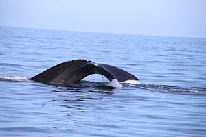
The tail of one of the right whales briefly sighted off Martha’s Vineyard Feb. 21, 2017. Photo credit: NOAA Fisheries/Pete Duley, NEFSC. Images collected under MMPA research permit #17355
OTTAWA, ON, CANADA – Oceana has released a new online tool that allows anyone to track ship speeds in speed zones designed to protect North Atlantic Right Whales along the east coast of the U.S. and Canada.
Using Global Fishing Watch data, which is a component of the new tool called Ship Speed Watch, Oceana Canada tracked ship speeds in the Cabot Strait from April 28 to June 15, 2020.
During the 49-day period, Transport Canada asked vessels longer than 13 meters to slow down to 10 knots.
Only a few complied, with 67 percent of the ships (464 out of 697) traveling faster than the 10-knot limit, and some traveling 20 knots or faster.
According to the organization, studies have found that slowing ship speeds to less than 10 knots in areas where these whales may be encountered, can reduce the lethality of collisions by 86 percent.
The Ship Speed Watch tool uses self-reported data to show ship locations, ship speeds and active voluntary and mandatory speed restriction zones.