


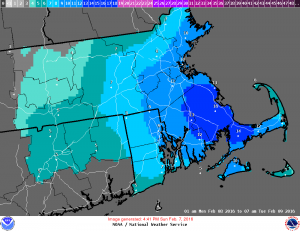
 BARNSTABLE – The National Weather Service has upgraded tomorrow’s storm warning to a blizzard warning.
High winds are expected on land and on the waters with low visibility at times.
The warning is in place from 4 a.m. Monday through 7 p.m. that night. A coastal flood watch is also in effect starting at 9 a.m. Monday and lasting through 1 p.m.
Daytime snow accumulation is expected to be in the 9 to 13 inch range for Southern Bristol and Southern Plymouth counties; 6 to 10 for the Cape and Martha’s Vineyard; 3 to 5 for Nantucket.
Eversource officials said the utility company is preparing for the weather. There are still some outages remaining from Friday’s storm.
Ahead of the impending conditions, the town of Bourne has cancelled the Special Town Meeting which was scheduled for 7 p.m. at the Bourne High School.
The meeting will now take place Tuesday, February 16th at 7 p.m. in the high school’s auditorium.
A parking ban in Dennis will begin at 11 p.m. Sunday night and last through 8 a.m. on Wednesday, February 10th. A parking ban was also in effect in Provincetown and Wareham.
The ban will allow public works crews to keep roadways clear during the storm. Vehicles parked on the roadways could be towed at the owner’s expense.
Additionally, the Cape Cod Regional Transit Authority (CCRTA) has cancelled all of Monday’s DART service.
As of Sunday evening, the Barnstable County Regional Emergency Planning Committee did not plan to open the regional shelters on Cape Cod, but would continue to monitor the forecast.


Speak Your Mind