


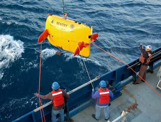
Photo Courtesy: Woods Hole Oceanographic Institution
WOODS HOLE – The National Transportation Safety Board is resuming its search for the data recorder of the sunken El Faro cargo ship.
All 33 crew members aboard the ship were killed including Massachusetts Maritime Academy graduates Keith Griffin, 33, and Jeffrey Mathias, 44.
In a statement Sunday, NTSB officials say their goal is to find the data recorder and “better document the wreckage to help determine exactly why and how the ship sank.”
The latest search effort will begin Monday when a research vessel departs from Charleston, S.C., and heads to the wreckage site near the Bahamas. The ship was found in 15,000 feet of water, its top two bridge decks detached.
Federal officials will be relying on equipment that was designed and built on Cape Cod to investigate the wreckage.
An autonomous underwater vehicle called SENTRY, which was developed by the Woods Hole Oceanographic Institution, will photograph and video document about 13.5 square miles of ocean.
“The primary mission will be to map the wreck and the associated debris field for the purposes of gaining an improved understanding surrounding the loss of the vessel,” said Andy Bowen, the principal engineer and director of national deep submergence facility for WHOI.
The data recorder is similar to the black box that is used in airplanes.
“That will be quite valuable if it’s possible to locate it in terms of understanding the final hours of the ship prior to its unfortunate sinking,” Bowen said.
Bowen said exploring the ocean with these types of technology can be difficult because there is not any real positioning information like Wi-Fi or GPS.
“So we have to kind of construct our own versions of communications and positioning,” Bowen said.
Researchers use acoustics to communicate with SENTRY.
“That’s essentially sound energy that’s transmitted through the water that is coded in such a way that it actually can be understood by the robot and allows us to pass information or instructions,” Bowen said.
“It’s a bit like having a drone but the only thing you can send to it is enough information packed into a yellow sticky.”
SENTRY is predominantly used for ocean sciences and is typically in use between 100 and 150 days a year in all of the world’s oceans.
It can operate to a maximum depth of 20,000 feet and has a range of sensors for mapping the ocean environment.
“It’s been used by biologists and geologists for understanding some of the mysteries of the world’s oceans,” Bowen said.


Speak Your Mind