


 HYANNIS – The National Weather Service has issued a Winter Storm Watch from Monday morning through Tuesday morning for the eastern half of Massachusetts including Cape Cod and the Islands and Plymouth and Bristol Counties.
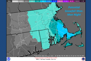
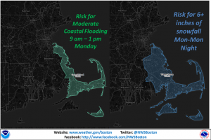
The snow is expected to be falling for the morning commute and accumulate throughout the day with a potential for over six inches of snow to fall.
The areas with the heaviest expected snowfall are Plymouth County and the Cape and Islands.
National Weather Service Meteorologist Alan Dunham said is could be a rough day for motorists.
“It will be impacting both the morning and evening commutes,” he said.
More snow should fall Monday night through early Tuesday morning with another one to three inches possible.
“This will still be a wet snow but not as wet as Friday’s snow was,” Dunham said. “I think that will help the situation a little bit but that will offer more drifiting.”
The high winds will also pose a risk of downed tree limbs and isolated power outages.
Eversource Energy spokesman Mike Durand said the utility is already planning for possible outages from the storm.
Sporadic outages remain on the Cape and Southeastern Mass from Friday’s storm.
A Coastal Flood Watch has also been issued for Plymouth County, Cape Cod and Nantucket for the late Monday morning high tide and into midday.
High astronomical tides will combine with strong onshore northeast winds of up to 45 mph which could cause a potential storm surge of 1.5 to 2 feet.
By BRIAN MERCHANT, CapeCod.com NewsCenter


Speak Your Mind