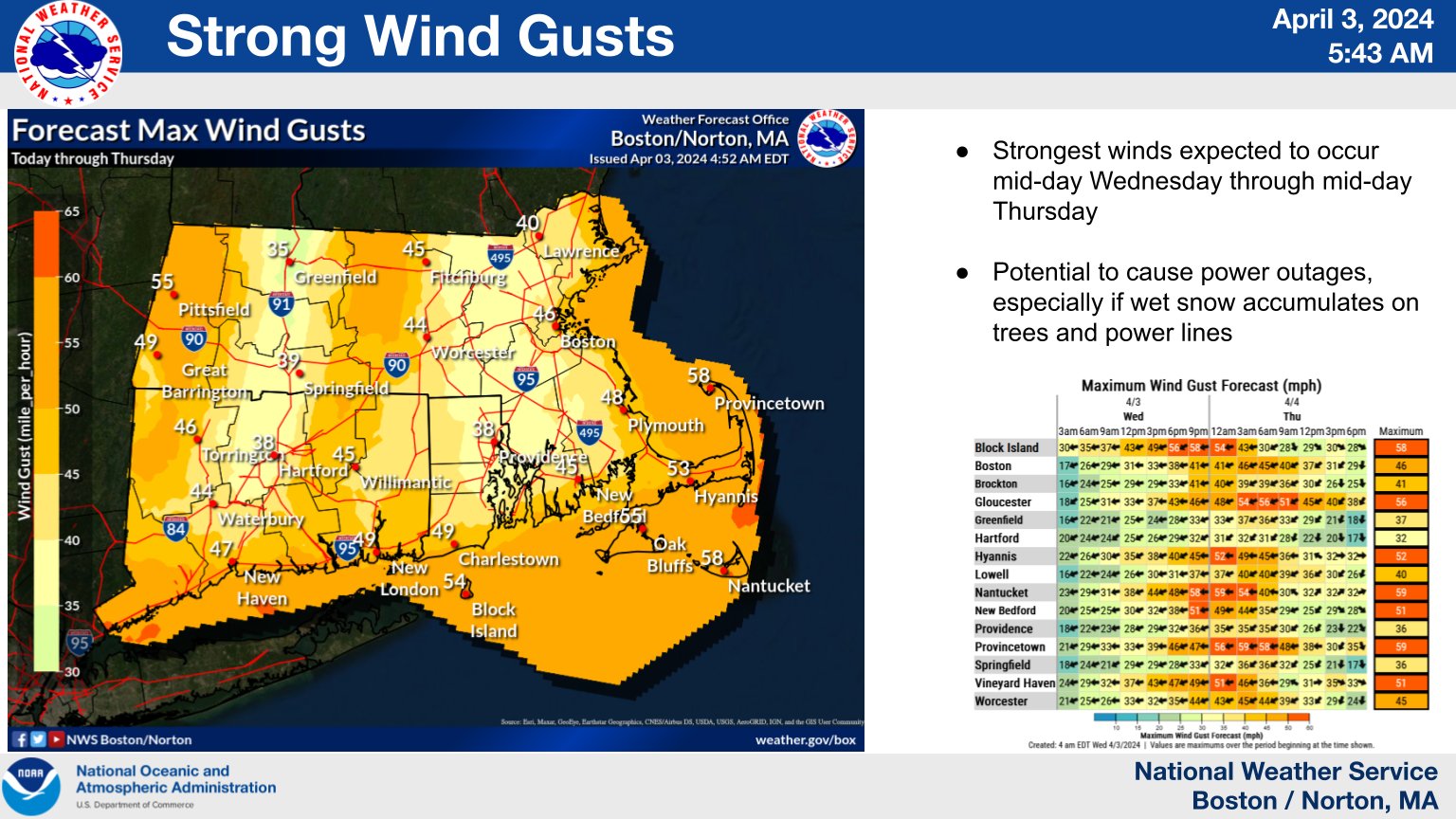
High Wind Warning
URGENT – WEATHER MESSAGE
National Weather Service Boston/Norton MA
351 AM EDT Wed Apr 3 2024
…HIGH WIND WARNING REMAINS IN EFFECT FROM 8 PM THIS EVENING TO 2 PM EDT THURSDAY…
* WHAT…East winds 30 to 40 mph with gusts up to 60 mph expected.
* WHERE…Eastern Norfolk, Suffolk, Eastern Essex, Barnstable, and Eastern Plymouth Counties.
* WHEN…From 8 PM this evening to 2 PM EDT Thursday.
* IMPACTS…Damaging winds will blow down trees and power lines. Widespread power outages are expected. Travel will be difficult, especially for high profile vehicles.
PRECAUTIONARY/PREPAREDNESS ACTIONS…
Remain in the lower levels of your home during the windstorm, and avoid windows. Watch for falling debris and tree limbs. Use caution if you must drive.
Coastal Flood Warning
Coastal Hazard Message
National Weather Service Boston/Norton MA
306 PM EDT Wed Apr 3 2024
…COASTAL FLOOD WARNING IN EFFECT FROM 6 AM TO 10 AM EDT THURSDAY…
* WHAT…One to two feet of inundation above ground level expected in low-lying areas near shorelines and tidal waterways (4.5 to 13.5 feet Mean Lower Low Water).
* WHERE…Eastern Essex MA, Suffolk MA, Eastern Norfolk MA, Eastern Plymouth MA, Barnstable MA, Dukes MA and Nantucket MA Counties.
* WHEN…During the Thursday morning high tide cycle.
* IMPACTS…Some vulnerable coastal roads become impassable around high tide. Flooding 1 to 2 feet deep affects some coastal roads and low lying areas from Revere and Winthrop through Boston to Hull, Braintree, and Quincy. Splashover and debris may wash onto coastal roads when large waves occur. Roads remain passable. Shallow pockets of flooding less than one foot deep affect more vulnerable coastal roads along the North Shore from Salem and Gloucester to Newburyport. Rough surf will likely cause some splashover onto coastal roads around the time of high tide. Roads remain passable. Low lying areas and roads near Nantucket Harbor, including Easy Street, may experience pockets of shallow flooding less than one foot deep. Some roads become impassable. Flooding 1 to 2 feet deep affects low lying areas around Edgartown Harbor, Vineyard Haven, and Oak Bluffs. This includes the Chappy Ferry Dock in Edgartown, Five Corners and Beach Road in Vineyard Haven, and East Chop Drive in Oak Bluffs. Splashover from waves affects Sea View Avenue in Oak Bluffs.
* ADDITIONAL DETAILS…
PRECAUTIONARY/PREPAREDNESS ACTIONS…
Take the necessary actions to protect flood-prone property. If travel is required, do not drive around barricades or through water of unknown depth.