 Cape Cod Weather: The Forecast
Check back here for up-to-the-minute forecasts, giving you highs, lows and all the information you need to plan your Cape Cod day, from Bourne to Provincetown.
We are proud to be your trusted source for local weather updates and information.
The Weather Outlook
On the road and need to know Cape Cod Weather?
Tune into Ocean 104.7 for weather updates every hour on the hour with current weather conditions and the latest forecast. Whether you are planning a day at the beach enjoying the Cape Cod sunshine or rainy day shopping the Cape’s main streets, you’ll want to know what to expect.
The Latest From the Ferries
Click HERE for Steamship Authority.
Click HERE for Hy-Line.
Useful Links:
- National Weather Service’s Local Weather Forecast – To provide you with further information about the area’s local weather, the National Weather Service displays current weather conditions, including temperature, humidity level, and wind speed. It also provides a short description of the weather forecasts over the next few days. Just enter your own zip!
- Marine Forecast and Coastal Water Temperatures -For insight into weather on the ocean, check out the Marine Forecast, which gives a detailed description of marine weather on the Cape and how it will affect the coast.We also have a map that displays the sea surface temperatures of sea surface temperatures in waters surrounding the Cape and Islands, including Buzzards Bay, Cape Cod Bay, Nantucket Sound and Vineyard Sound.In addition, you can also find out information regarding tides across the Cape, including heights and high and low tides from throughout the region.
- National Hurricane Center – Though Cape Cod is only a sliver in the United States, it’s important to be aware of potential storms in other parts of the country that could affect our region, which is precisely what the National Hurricane Center does. In addition to a map showing where hurricane activity is occurring throughout the country, the site also provides links for active storms, marine forecasts, dates for hurricane season, and tips for hurricane preparedness.
- Eversource (formerly NSTAR) Storm Center – Looking for how to deal with a power outage both effectively and safely? Look no further than the NStar Storm Center, which provides you with all the information you need to know if your power goes out. On the site, you’ll find a map that shows where various outages have occurred and how many customers are out of power. It also provides customers with the opportunity to receive texts during a storm that updates them on the current impact of the storm and what NStar is doing to combat it. They also present steps to take when the power does go out, safety precautions to take after the storm is over, and tips for generator safety.
Cape Cod Weather History
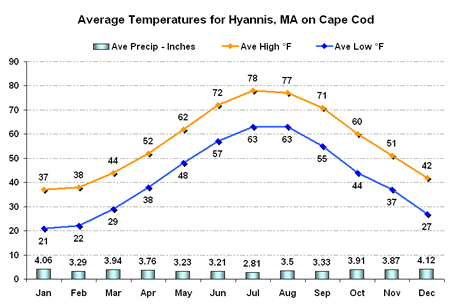
Typically, Cape Cod sees its warmest month of the year in July, with the average highest temperature reaching 78° and a low of 63°. August sees an average high of 77°, and the low average of 63° carrying over from July.
In addition to what’s happening locally, we also want to provide you with other resources that explain weather patterns and preparedness tips. That’s why we have links to websites that will give you quality information on a variety of weather-related topics, like the best way to manage a power outage in the event of a storm.


