


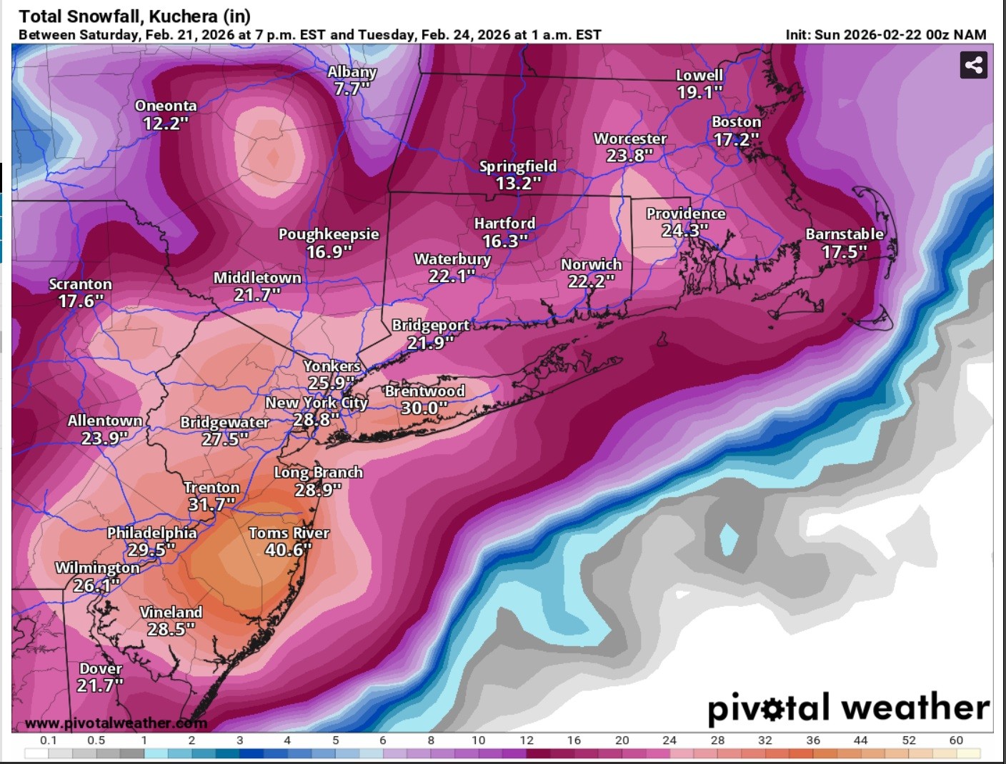
Potential snow accumulations
(HYANNIS) – A major Nor’easter was forecast to bring a significant winter storm to Cape Cod and the Islands late Sunday night into much of the day on Monday, bringing heavy, wet snow, high winds and coastal flooding.
The National Weather Service posted a Blizzard Warning for all of Cape Cod and much of eastern Massachusetts though late Monday and Gov. Maura Healey declared a State of Emergency for Massachusetts.
Snow totals across the Cape were expected to range from 18 to 20 inches on the Upper Cape, around 18 inches in the Mid Cape and a foot on the Lower and Outer Cape. Nantucket was expected to see lesser amounts due to a possible mixing with rain.
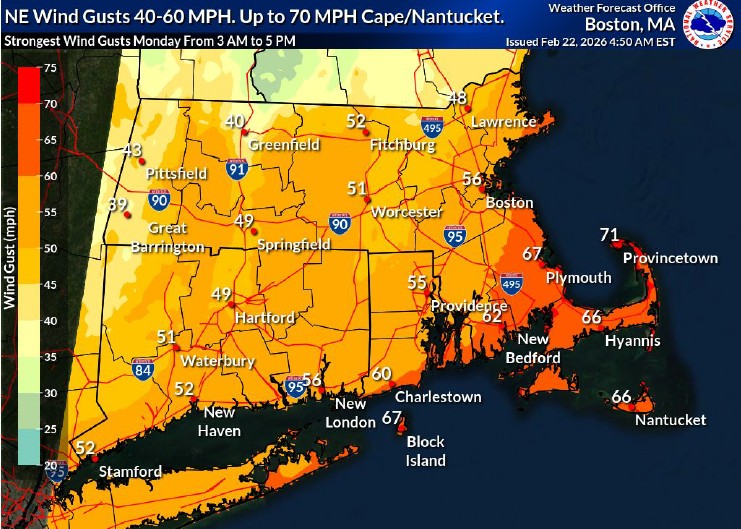
Potential wind gusts
The National Weather Service said peak snowfall rates would likely happen late Sunday night into Monday before snow tapers off on Monday night. There was also the likelihood of widespread 50 to 60 mph gusts on Cape Cod and the Islands and most of the coastal waters, with the possibility of some gusts hitting 70 mph.
At the height of the storm, snowfall rates could fall at 3 inches per hour.
Below are several storm related resources and information:
Report Power Out: 1-800-592-2000
Eversource Outage Map:
https://outagemap.eversource.com/external/default.html
Sign Up for Power Outage Notifications
https://www.eversource.com/residential/outages/outage-alerts
Safety and preparedness tips for nor’easters and coastal storms: https://www.mass.gov/…/noreaster-coastal-storm-safety-tips
Power outage preparedness and safety information: https://www.mass.gov/info-details/power-outage-safety-tips
Flood safety tips: https://www.mass.gov/info-details/flood-safety-tips

Timing of heaviest snow
The State Fire Marshal’s office reminded residents about the dangers of carbon monoxide during a storm of this magnitude. Heating equipment, generators, and blocked vehicle exhausts all contribute to CO poisoning events. They urged people to keep those vents clear and be sure CO alarms are working properly with fresh batteries in the event of power outages.
This would be the latest in a string of winter storms that have brought significant snows to New England during the winter of 2026.
This event was likely to bring a wetter snow with significantly stronger winds than the storm that brought up to a foot of snow or more to Cape Cod in January. That would result in the possibility of more power outages due to the weight of the snow and the higher winds.
Barnstable County Emergency Management officials were working on coordinating the need for shelters. On the Lower and Outer Cape, the Nauset Regional High School shelter was scheduled to open on Sunday at 6 p.m. A shelter at the Cape Cod Regional Technical High School in Harwich was scheduled to open Sunday at 6 p.m. The Barnstable Intermediate School shelter will open at 8 p.m.
High astronomical tides Monday into Tuesday also brings the potential for minor to moderate coastal flooding along the eastern coast, depending on the timing of the highest surge.
Here are the official warnings from the National Weather Service:
BLIZZARD WARNING IN EFFECT FROM 4 PM SUNDAY TO 7 AM EST TUESDAY…
* WHAT…Blizzard conditions expected. Total snow accumulations between 1 and 2 feet. Winds gusting as high as 60 mph.
* WHERE…Portions of eastern, northeastern, and southeastern Massachusetts and northern and southern Rhode Island. This includes Boston to Providence corridor.
* WHEN…From 4 PM Sunday to 7 AM EST Tuesday.
* IMPACTS…Visibilities may drop below 1/4 mile due to falling and blowing snow. The strong winds and weight of snow on tree limbs may down power lines and could cause power outages. Whiteout conditions are expected and will make travel treacherous and potentially life-threatening. Travel could be very difficult to impossible. The hazardous conditions will impact the Monday morning and evening commutes. Strong winds could cause tree damage.
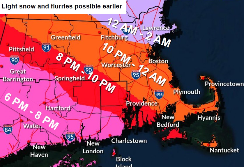
Onset of storm conditions
PRECAUTIONARY/PREPAREDNESS ACTIONS…
Travel should be restricted to emergencies only. If you must travel, have a winter survival kit with you. If you get stranded, stay with your vehicle.
COASTAL FLOOD WARNING IN EFFECT FROM 1 AM TO 7 AM EST MONDAY…
* WHAT…Two to three feet of inundation above ground level expected in low-lying areas near shorelines and tidal waterways (4.5 to 13.5 feet Mean Lower Low Water).
* WHERE…Eastern Plymouth MA, Barnstable MA, Dukes MA and Nantucket MA Counties.
* WHEN…From 1 AM to 7 AM EST Monday.
* IMPACTS…Many roads near Nantucket Harbor become impassable with 1 to 2 feet of water and affects access to the ferry terminals. This includes Easy Street, South Beach Street, Easton Street, Walsh Street, Willard Street, and Straight Wharf. Many coastal roads become impassable with flooding 1 to 3 feet deep. This includes the Chappy Ferry Dock and Dock Street near Edgartown Harbor. In Vineyard Haven, Five Corners, Beach Road, and Water Street become impassable. In Oak Bluffs, flooding affects East Chop Drive, the section of Lake Avenue near Oak Bluffs Harbor, and Sea View Avenue, where debris may also wash onto the roadway.
PRECAUTIONARY/PREPAREDNESS ACTIONS…
Take the necessary actions to protect flood-prone property. If travel is required, do not drive around barricades or through water of unknown depth.
Officials with Eversource said they were continuing to monitor and prepare for the powerful Nor’easter expected to bring heavy snow and strong winds on Sunday night and into Monday.
Their crews were ready to respond to any power outages as quickly and safely as possible. They noted that high winds could delay the ability for line crews to go up into bucket trucks delaying restoration efforts. Based on the possible intensity of the storm, utility officials said any outages could be a multi-day event. Verizon officials also said they had crews ready to respond to service interruptions.
Most municipal offices across Cape Cod were expected to be closed on Monday, as were schools. The Steamship Authority canceled all trips for Monday and the Cape Cod Regional Transit Authority suspended service on Monday.
The Town of Barnstable Transfer Station and Recycling Center, located at 45 Flint Street, Marstons Mills, will be temporarily closed on Monday, February 23, 2026. Trash and recycling services are expected to resume on a normal schedule on Tuesday, February 24, 2026, weather permitting.


