




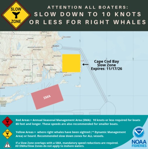
 CAPE COD BAY – The National Oceanic and Atmospheric Administration (NOAA) has established a voluntary vessel slow zone in Cape Cod Bay following the detection of endangered North Atlantic right whales in the area.
According to NOAA Fisheries, a monitoring buoy operated by the Woods Hole Oceanographic Institution detected the presence of right whales on November 2, 2026, prompting the designation of a slow zone that will remain in effect through November 17.
Mariners are being asked to avoid the designated area when possible or reduce their speeds to 10 knots or less while traveling through the zone.
The voluntary speed restrictions are intended to reduce the risk of collisions between vessels and North Atlantic right whales, one of the world’s most endangered large whale species.
Vessel strikes are among the leading causes of serious injuries and deaths for right whales. NOAA officials say reducing vessel speeds can lessen the severity of collisions and give boat operators additional time to detect and avoid whales.
North Atlantic right whales regularly travel through waters off Cape Cod, including Cape Cod Bay, which serves as an important feeding habitat for the species.
The whales are particularly vulnerable to vessel strikes because they often swim near the surface and can be difficult for boat operators to detect.
NOAA establishes temporary slow zones when right whales are detected through acoustic monitoring systems or visual sightings. The designations are intended to alert mariners to the presence of whales and encourage additional precautions.
The latest designation applies to the Cape Cod Bay area where the whales were detected. Unlike mandatory vessel speed restrictions in certain designated waters, compliance with the temporary slow zone is voluntary.
Boaters, commercial vessel operators and other mariners are encouraged to monitor NOAA advisories for updates on whale activity and additional slow zones that may be established.
More information, including maps and a current list of active right whale slow zones, is available on the NOAA Fisheries website
Copyright Pitta Media Group 2026. Any unauthorized use not permitted. All rights reserved.