


All warnings have now expired. No reports of significant damage or injuries has been reported. 2,700 Eversource customers are without power in Barnstable and Sandwich with over 500 out in Dennis and Yarmouth with scattered outages elsewhere across the Cape. Lightning strikes are believed to be the cause. Line crews are working to restore service.
Below are the warnings as they were received.
Special Weather Statement
Special Weather Statement
National Weather Service Boston/Norton MA
944 PM EDT Sat Jul 29 2023
…A strong thunderstorm will impact portions of Dukes, southwestern Barnstable and southeastern Bristol Counties through 1030 PM EDT…
At 944 PM EDT, Doppler radar was tracking a strong thunderstorm near Gosnold, or 10 miles southeast of Dartmouth, moving southeast at 35 mph.
HAZARD…Wind gusts up to 50 mph.
SOURCE…Radar indicated.
IMPACT…Strong winds could cause minor damage such as downed branches.
Locations impacted include…
Falmouth, Oak Bluffs, Edgartown, Tisbury, Aquinnah, Fairhaven, Mattapoisett, West Tisbury, Chilmark and Gosnold.
PRECAUTIONARY/PREPAREDNESS ACTIONS…
Get indoors when you hear thunder. Do not resume outdoor activities until at least 30 minutes after the storm has passed.
Do not drive through flooded roads or underpasses. Avoid low lying areas near small streams.
Frequent cloud to ground lightning is occurring with this storm. Lightning can strike 10 miles away from a thunderstorm. For your safety, go indoors or to your vehicle.
Severe Thunderstorm Warning
BULLETIN – IMMEDIATE BROADCAST REQUESTED
Severe Thunderstorm Warning
National Weather Service Boston/Norton MA
916 PM EDT Sat Jul 29 2023
The National Weather Service in Boston/Norton has issued a
* Severe Thunderstorm Warning for…
Northeastern Barnstable County in southeastern Massachusetts…
* Until 945 PM EDT.
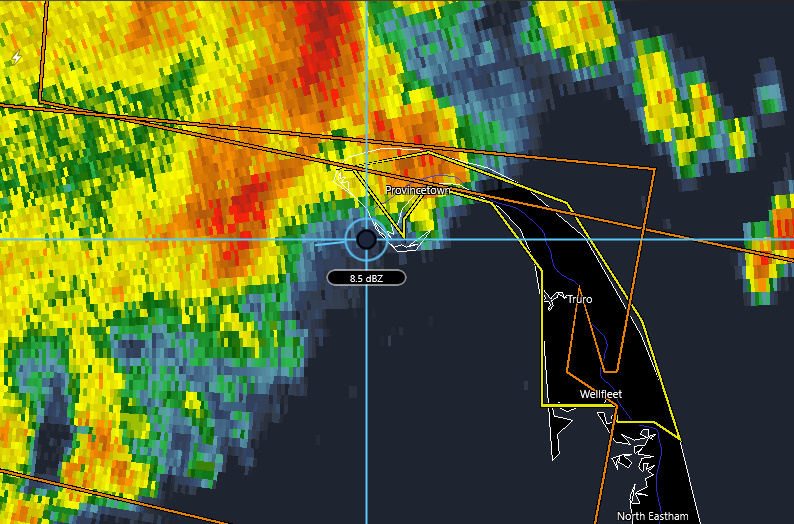
* At 916 PM EDT, a severe thunderstorm was located near Provincetown, moving east at 40 mph.
HAZARD…60 mph wind gusts.
SOURCE…Radar indicated.
IMPACT…Expect damage to trees and power lines.
* Locations impacted include…
Provincetown, Wellfleet and Truro.
PRECAUTIONARY/PREPAREDNESS ACTIONS…
For your protection move to an interior room on the lowest floor of a building.
Large hail and damaging winds and continuous cloud to ground lightning is occurring with this storm. Move indoors immediately. Lightning is one of nature`s leading killers. Remember, if you can hear thunder, you are close enough to be struck by lightning.
Special Weather Statement
Special Weather Statement
National Weather Service Boston/Norton MA
839 PM EDT Sat Jul 29 2023
…Strong thunderstorms will impact portions of northwestern Dukes, western Barnstable, south central Plymouth, southeastern Bristol, Washington, Newport, Kent, southeastern Providence and Bristol Counties through 945 PM EDT…
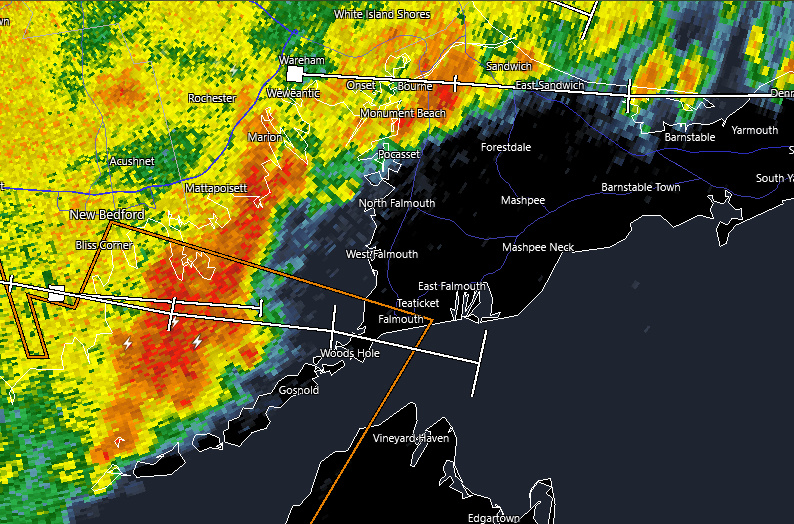
At 839 PM EDT, Doppler radar was tracking strong thunderstorms along a line extending from Coventry to near West Greenwich to 6 miles east of Ledyard. Movement was east at 40 mph.
HAZARD…Wind gusts up to 50 mph.
SOURCE…Radar indicated.
IMPACT…Strong winds could cause minor damage such as downed branches.
Locations impacted include…
New Bedford, Fall River, Warwick, Cranston, Coventry, Dartmouth, Falmouth, South Kingstown, West Warwick, North Kingstown, Newport, Bristol, Marion, Westerly, Wareham, Bourne, Somerset, Portsmouth, Barrington and Middletown.
PRECAUTIONARY/PREPAREDNESS ACTIONS…
Get indoors when you hear thunder. Do not resume outdoor activities until at least 30 minutes after the storm has passed.
Do not drive through flooded roads or underpasses. Avoid low lying areas near small streams.
Frequent cloud to ground lightning is occurring with these storms. Lightning can strike 10 miles away from a thunderstorm. For your safety, go indoors or to your vehicle.
These storms may intensify and become severe. Stay tuned to your local media for updates and possible warnings.
A Severe Thunderstorm Watch remains in effect until 900 PM EDT for southeastern Massachusetts…and Rhode Island.

Severe Thunderstorm Warning
BULLETIN – IMMEDIATE BROADCAST REQUESTED
Severe Thunderstorm Warning
National Weather Service Boston/Norton MA
839 PM EDT Sat Jul 29 2023
The National Weather Service in Boston/Norton has issued a
* Severe Thunderstorm Warning for…
Central Dukes County in southeastern Massachusetts…
Barnstable County in southeastern Massachusetts…
Plymouth County in southeastern Massachusetts…
Bristol County in southeastern Massachusetts…
Northeastern Newport County in Rhode Island…
East central Providence County in Rhode Island…
Northeastern Bristol County in Rhode Island…
* Until 945 PM EDT.
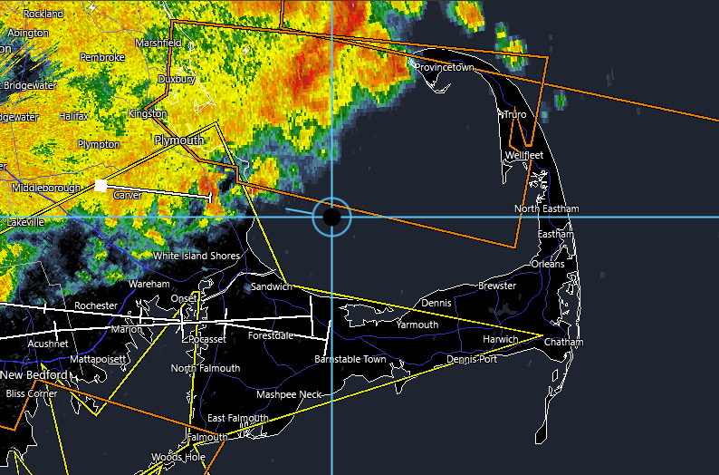
* At 839 PM EDT, severe thunderstorms were located along a line extending from near Duxbury to near Seekonk, moving southeast at 30 mph.
HAZARD…60 mph wind gusts.
SOURCE…Radar indicated.
IMPACT…Expect damage to trees and power lines.
* Locations impacted include…
Providence, New Bedford, Brockton, Fall River, Pawtucket, Plymouth, Taunton, East Providence, Barnstable, Dartmouth, Falmouth, Bridgewater, Marshfield, Marion, Oak Bluffs, Edgartown, Tisbury, Aquinnah, Attleboro and Yarmouth.
PRECAUTIONARY/PREPAREDNESS ACTIONS…
For your protection move to an interior room on the lowest floor of a building.
Large hail and damaging winds and continuous cloud to ground lightning is occurring with these storms. Move indoors immediately. Lightning is one of nature`s leading killers. Remember, if you can hear thunder, you are close enough to be struck by lightning.
Torrential rainfall is occurring with these storms, and may lead to flash flooding. Do not drive your vehicle through flooded roadways.
Severe Thunderstorm Watch
Severe thunderstorm watch outline update for WS 568
NWS Storm prediction center Norman OK
130 PM EDT Sat Jul 29 2023
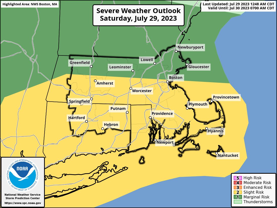
Severe thunderstorm watch 568 is in effect until 9:00 PM EDT for the following locations
MA
. Massachusetts counties included are:
Barnstable, Berkshire, Bristol, Dukes, Essex, Franklin, Hampden, Hampshire, Middlesex, Nantucket, Norfolk, Plymouth, Suffolk, Worcester


