




bo082222 Flooding by Sagamore Bridge from Cape Wide News LLC on Vimeo.
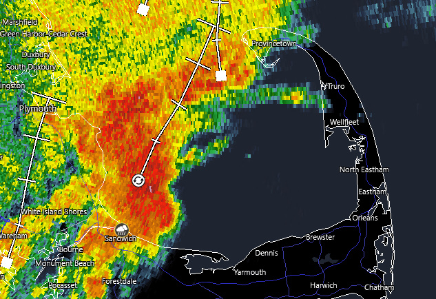
BOURNE – Large puddles were reported on Route 6 eastbound by the Market Basket on the Cape side of the Sagamore Bridge as seen in video captured by a MassDOT traffic camera. There was a report of at least one stalled vehicle and traffic was at a near standby. The Bourne Bridge may be a better bet for a while. MassDOT crews were working to relieve the flooding. By 2:30 PM, radar showed the heaviest of the rain was moving into Cape Cod Bay: Update: 4:45 PM Traffic was still at a standstill coming onto the Cape over the Sagamore Bridge as MassDOT continued to clear debris left by the flooding. The Bourne Bridge continues to be the better bet.
On Shore Road in Bourne, DPW workers had to push this Ford Transit Connect out of deep water:

David Curran/Satellite News Service/CWN (used with permission)
Previous weather statements:
Special Weather Statement
National Weather Service Boston/Norton MA
423 PM EDT Mon Aug 22 2022
…Strong thunderstorms will impact portions of northeastern Barnstable County through 530 PM EDT…
At 422 PM EDT, Doppler radar was tracking strong thunderstorms along a line extending from 13 miles northeast of Provincetown to near Eastham. Movement was northeast at 25 mph.
HAZARD…Winds in excess of 40 mph, along with cloud to ground lightning.
SOURCE…Radar indicated.
IMPACT…Strong winds could cause minor damage such as downed branches.
Locations impacted include…Eastham, Wellfleet and Truro.
PRECAUTIONARY/PREPAREDNESS ACTIONS…
Get indoors when you hear thunder. Do not resume outdoor activities until at least 30 minutes after the storm has passed.
Special Weather Statement
National Weather Service Boston/Norton MA
152 PM EDT Mon Aug 22 2022
…A thunderstorm producing heavy rain will impact portions of southwestern Barnstable and southeastern Plymouth Counties through 245 PM EDT…
At 150 PM EDT, Doppler radar was tracking a strong thunderstorm over Bourne, or 9 miles northwest of Barnstable, moving north at 15 mph. As much as 1.5 inches of rain have fallen in far western Barnstable County from this thunderstorm.
HAZARD…Minor nuisance flooding.
SOURCE…Radar indicated.
IMPACT…Minor nuisance flooding of typically flood prone areas. Be alert for the dangers of hydroplaning.
Locations impacted include…
Plymouth, Barnstable, Falmouth, Wareham, Sandwich, Bourne and Mashpee.
PRECAUTIONARY/PREPAREDNESS ACTIONS…
Do not drive through flooded roads or underpasses. Avoid low lying areas near small streams.