


Red Flag Warning
URGENT – FIRE WEATHER MESSAGE
National Weather Service Boston/Norton MA
310 AM EDT Tue Sep 22 2020
…RED FLAG WARNING IN EFFECT FROM 9 AM THIS MORNING TO 9 PM EDT THIS EVENING FOR ALL OF MASSACHUSETTS AND RHODE ISLAND…
* AFFECTED AREA…All of Massachusetts and Rhode Island.
* TIMING…From mid morning through 9 PM this evening.
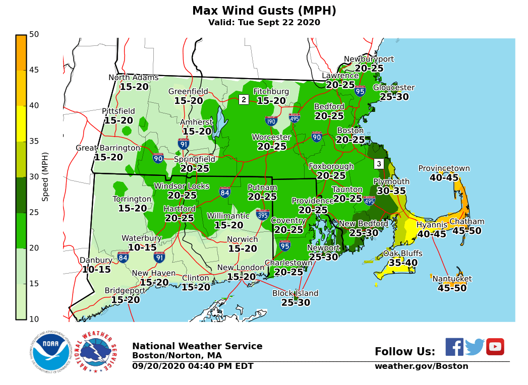
* WINDS…North winds. Wind gusts of 25 to 30 mph across the interior and between 30 and 40 mph along the coast. The strongest of the winds will be across the Cape and Islands where 45 to 55 mph gusts are expected.
* RELATIVE HUMIDITY…Minimum values between 20 and 35 percent with the lowest values across the interior.
* TEMPERATURES…In the 60s to near 70 this afternoon.
* IMPACTS…Dry weather and gusty winds will result in critical fire weather conditions.
PRECAUTIONARY/PREPAREDNESS ACTIONS…
A Red Flag Warning means that critical fire weather conditions are either occurring now, .or will shortly. Any fires that start may spread rapidly and become difficult to extinguish.
Wind Advisory
URGENT – WEATHER MESSAGE
National Weather Service Boston/Norton MA
305 AM EDT Tue Sep 22 2020
…WIND ADVISORY REMAINS IN EFFECT FROM 9 AM THIS MORNING TO 11 PM EDT THIS EVENING…
* WHAT…North winds 25 to 35 mph with gusts up to 55 mph expected.
* WHERE…Barnstable MA County.
* WHEN…From 9 AM this morning to 11 PM EDT this evening. Strongest of the winds will occur this afternoon in the Hyannis to Chatham areas.
* IMPACTS…Gusty winds could blow around unsecured objects. Tree limbs could be blown down and a few power outages may result.
PRECAUTIONARY/PREPAREDNESS ACTIONS…
Use extra caution when driving, especially if operating a high profile vehicle. Secure outdoor objects.
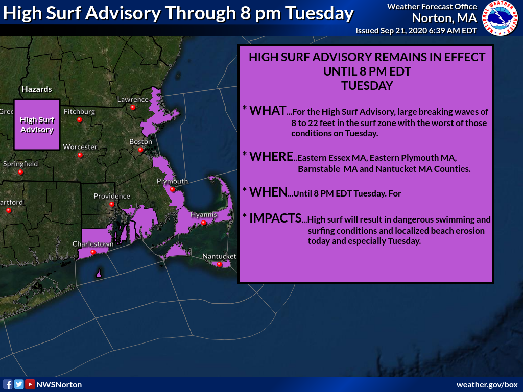
High Surf Advisory
Coastal Hazard Message
National Weather Service Boston/Norton MA
320 AM EDT Tue Sep 22 2020
…HIGH SURF ADVISORY NOW IN EFFECT UNTIL 8 PM EDT WEDNESDAY…
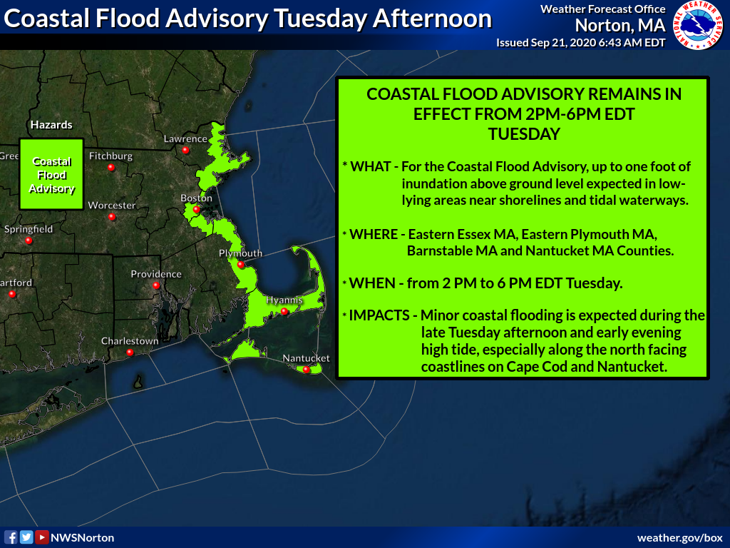
…COASTAL FLOOD ADVISORY NOW IN EFFECT FROM 2 PM THIS AFTERNOON TO 7 PM EDT THIS EVENING…
* WHAT…For the High Surf Advisory, large breaking waves of 8 to 24 feet in the surf zone. For the Coastal Flood Advisory, one to two feet of inundation above ground level expected in low-lying areas near shorelines and tidal waterways. This will result in widespread minor coastal flooding along the eastern Massachusetts coastline and particularly the north facing coastline of Cape Cod and Nantucket.
* WHERE…The Eastern MA coastline as well as the Cape and Islands.
* WHEN…For the High Surf Advisory, until 8 PM EDT Wednesday. For the Coastal Flood Advisory, from 2 PM this afternoon to 7 PM EDT this evening.
* IMPACTS…Coastal flooding is expected along the North Shore from Marblehead northward along the coast to Newburyport. The combination of high tides and large swells will result in flooding of some immediate coastal roads and some road closures are anticipated. Flooding of Nantucket Harbor is expected. Some low-lying coastal roads, including Easy and Easton Streets, will experience flooding during the time nearest high tide. Expect minor coastal flooding of some low-lying roadways. Minor coastal flooding occurs in Provincetown, in the vicinity of Race Point Road and Provincetown Airport. In Truro backwater flooding occurs along the Pamet River. Dangerous swimming and surfing conditions and localized beach erosion.
PRECAUTIONARY/PREPAREDNESS ACTIONS…
If travel is required, allow extra time as some roads may be closed. Do not drive around barricades or through water of unknown depth. Take the necessary actions to protect flood-prone property.
Inexperienced swimmers should remain out of the water due to dangerous surf conditions.

Special Weather Statement
Special Weather Statement…CORRECTED
National Weather Service Boston/Norton MA
355 PM EDT Sun Sep 20 2020
…ELEVATED FIRE WEATHER ON MONDAY…
The prolonged dry weather across southern New England has resulted in very low live and dead fuel moisture. With low relative humidity and gusty winds Monday, any fires which escape initial containment and become established, could potentially become serious.
Consult your local fire warden if planning any outdoor burning on Monday.


