




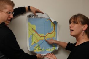
This April Fool’s Day make sure tourists know about new plans for a subway system for the Cape and Islands.
If you’re a Cape Codder, you might dread leaving the house in the summer.
The number of cars on the road increases exponentially and what would normally be a quick trip to the store can turn into hours on the road.
Former Falmouth residents Damia and Rob Stewart dreamed up the idea for a subway serving Cape Cod. The “Red Line” runs from Plymouth to Provincetown with a stop off at 4 C’s. Those getting on the “Green Line”, which starts at Buzzards Bay would connect travelers to the Islands. A radical “Blue Line” would take travelers under water from Provincetown to the Mid-Cape and then continues to Martha’s Vineyard and Nantucket.
Who wouldn’t want to be shuttled straight to the Steamship Authority or whisked over the Wellfleet without the hours of sitting in traffic behind cars with out of state license plates? Apparently quite a few of us.
The Stewarts have been selling these maps on www.transitauthorityfigures.com In addition to subway grids for Cape Cod, they’ve also created maps with fictional transport plans for other locations including Vermont, The Hamptons, and Providence.
By Rebecca Romo, Lifestyle Reporter CapeCod.com
 About Rebecca Romo