


 CHATHAM – After looking at the Northeast Ocean Data Portal, a major energy company wanted to propose a wind farm in the Gulf of Maine in an area where they saw no documented fishing activity.
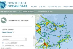
The Portal pulls together huge amounts of information on every conceivable ocean use, from cultural resources to marine transportation to fishing activity. The fishing data is robust and includes information from dockside reports and vessel tracking systems.
But then they called Annie Hawkins, executive director of Responsible Offshore Development Alliance, RODA. She suspected the area was hugely important to the lobster industry and was certainly used — a lot.
Current regulations don’t require lobstermen to have vessel tracking systems. Where they fish isn’t plugged into any standardized data collection, so it doesn’t show up on the Portal.
“That could have gone in the very wrong direction,” Hawkins said.
She is quick to add the portal does show an incredible amount, and has been useful in a number of instances.
But there are big gaps. When the portal was first being set up a decade or so ago, it was part of a larger “ocean planning” process from which many fishermen felt excluded, said Hawkins. That led to fishermen not providing insight, and a lot of relevant information wasn’t included.
Adding to the issue is the convoluted, changing world of fisheries and fisheries management. Two examples: (1) fishing effort in areas being shown on the portal for years when areas were closed, or when the fish aren’t there and (2) the inability to show effort of one or two captains whose entire business plan hangs on using a specific area. (Since information specific to individual fishermen can’t be used for confidentiality reasons the portal shows those areas aren’t used.)
To fix those problems, RODA, made up of fishing industry members, recently started an initiative partnering with the Northeast Regional Ocean Council, which runs the portal and where Nick Napoli leads development, and the Mid-Atlantic Regional Council on the Ocean.
“A bunch of people in the industry said we want to improve this. That is not to take anything away from Nick and his team,” Hawkins said.
Napoli welcomes RODA as well as suggestions from individual fishermen. He has federal grants to update the portal.
George Maynard, research coordinator at the Fishermen’s Alliance, said efforts to update the portal were valuable, especially with myriad projects in the pipeline. But, he cautioned, like with any data set, people using the portal need to understand its limitations. The oceans are a complex place, and no one source has all of the information that people need to make decisions.
“That’s why it’s critical for offshore infrastructure developers to make a genuine effort to connect with different facets of the fishing industry. RODA does a great job of bringing the fishing industry together and providing an outlet for our voices, whether that’s in the regulatory and planning process or in efforts to make more information available to decision makers.”
Napoli said the portal already has “Communities at Sea” maps meant to help focus and guide essential engagement with fishing communities for ocean planning, permitting, and management decision-making. For example, when an activity or project is being considered for a location off New England, the maps can be used to see which communities could be most affected, and direct focus there.
But, he added, those maps need updating.
The portal was designed in 2009 to capture far more than fishing activity, including coastal and ocean planning and management, regulatory and siting issues, education and research. It was used as the foundation for the Northeast Ocean Plan, which after years of work was certified by the National Ocean Council in 2016.
Napoli said the portal continues to play an important role providing easily accessible, expert-reviewed data for a range of government agencies, businesses and ocean stakeholders. The portal contains more than 5,000 maps, a number that’s growing.
“Every map has its own story,” said Napoli. “It’s confusing out there.”
The gathered material can be particularly helpful during a formal comment period when stakeholders are asked to offer opinions on projects or changes in management, and need data to back up their ideas.
For instance, when the New England Fishery Management Council put forward a Deep Sea Coral Amendment, with closure options, stakeholders were able to make more informed comments.
“I would say that a lot of the data is used in regulatory actions,” Napoli said.
Council members have used it in other ways as well: when a series of underwater cables was planned in fishing areas, managers were able to recommend appropriate siting of one trench rather than several, minimizing construction impacts to conch and other fisheries.
The portal is seeing increased usage in the last year. “I think it’s because (offshore) wind has become more of a concern,” said Napoli. “That’s part of it.”
RODA will be asking fishermen what maps they would like to see, including ways to handle areas that a few fishermen use, but where loss of access could still be economically devastating.
“Our goal is to better represent fishermen in everything related to other ocean uses,” Hawkins said. “We need to make sure their voices are heard to get the best outcomes.”
To find out more about RODA’s efforts or suggest additions to the portal e-mail Fiona. ([email protected])


