


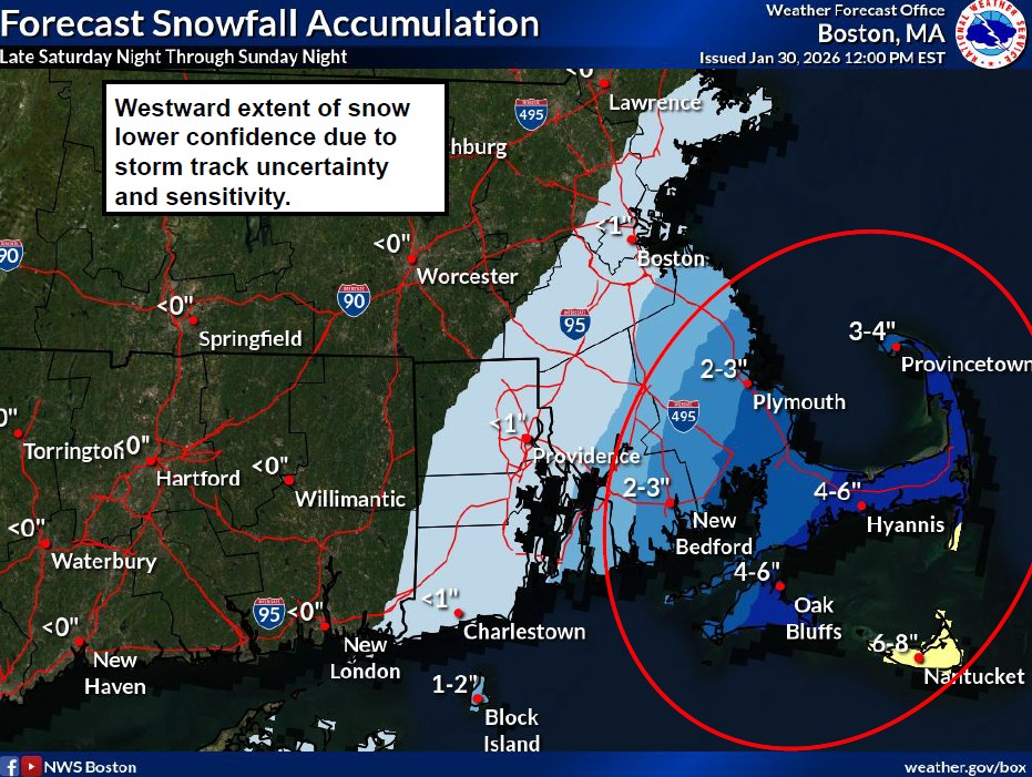
Potential snow accumulations
HYANNIS – A busy storm pattern continues this winter as forecasters are looking at another weekend storm, this time with the possibility of stronger winds and higher tides.
Meteorologists with the National Weather Service said there is the potential for coastal flooding and erosion along the eastern Massachusetts coast Sunday into Monday due to high astronomical tides, storm surge, and wave action.
If the current tracks hold, Cape Cod will see 4 to 6 inches of snow, with perhaps more on the Outer Cape and Nantucket.
The questions that are still unanswered for forecasters include how close the storm tracks to southern New England, how strong the storm becomes, and timing of the highest storm surge (high tide vs low tide). The tides of greatest concern would be the daytime high tides on Sunday (with northeast winds) and Monday (with north winds).
Barnstable County Emergency Management officials said they were prepared to open shelters if necessary after the storm.
The National Weather Service issued the following advisories for winter weather and coastal flooding:
URGENT - WINTER WEATHER MESSAGE
National Weather Service Boston/Norton MA
827 AM EST Sat Jan 31 2026...WINTER WEATHER ADVISORY REMAINS IN EFFECT FROM 4 AM SUNDAY TO 4 AM EST MONDAY...
* WHAT...Snow expected. Total snow accumulations between 1 and 3 inches. Winds gusting as high as 45 mph.
* WHERE...Barnstable MA, Dukes MA, Eastern Plymouth MA, and Nantucket MA Counties.
* WHEN...From 4 AM Sunday to 4 AM EST Monday.
* IMPACTS...Plan on slippery road conditions. Gusty winds could bring down tree branches.
PRECAUTIONARY/PREPAREDNESS ACTIONS...
Slow down and use caution while traveling.
...WIND ADVISORY REMAINS IN EFFECT FROM 5 AM TO 11 PM EST SUNDAY...
* WHAT...North winds 25 to 35 mph with gusts between 40 and 50 mph. A few brief gusts up to 55 mph possible for Nantucket.
* WHERE...Barnstable MA, Dukes MA, and Nantucket MA Counties.
* WHEN...From 5 AM to 11 PM EST Sunday.
* IMPACTS...Gusty winds will blow around unsecured objects. Tree limbs could be blown down and some power outages may result.
PRECAUTIONARY/PREPAREDNESS ACTIONS...
Winds this strong can make driving difficult, especially for high profile vehicles. Use extra caution.
Barnstable MA-
Including the cities of Provincetown, Chatham, and Falmouth
1121 AM EST Thu Jan 29 2026...COASTAL FLOOD ADVISORY IN EFFECT FROM 8 AM SUNDAY TO 2 PM EST MONDAY...
* WHAT...One to two feet of inundation above ground level expected in low-lying areas near shorelines and tidal waterways (4.2 to 13.4 feet Mean Lower Low Water).
* WHERE...Barnstable MA and Dukes MA Counties.
* WHEN...Multiple high tide cycles Sunday morning into Monday afternoon.
* IMPACTS...Pockets of shallow flooding less than one foot deep. This mainly affects low lying areas and roads near Edgartown Harbor, including the Chappy Ferry Dock. Shallow flooding may also approach Five Corners in Vineyard Haven.
* ADDITIONAL DETAILS...Sub-freezing temperatures and cold road surfaces may allow for some of the storm surge to freeze. This would result in prolonged issues on those vulnerable roadways and also delay drainage.
PRECAUTIONARY/PREPAREDNESS ACTIONS...
If travel is required, allow extra time as some roads may be closed. Do not drive around barricades or through water of unknown depth. Take the necessary actions to protect flood-prone property.
Snow starting times
According to the National Weather Service:
Lower-End Scenario (More Offshore Storm Track):
• Minor coastal flooding (up to 1 foot)
• Storm surge of 1 to 2 feet
• Beach erosion with offshore seas exceeding 25 feet
Higher-End Scenario (Closer Storm Track and Surge Near High Tide):
• Moderate (2–3 feet) to locally major (3+ feet) coastal flooding
• Storm surge of 3 to 4 feet
• Significant beach erosion with offshore seas exceeding 25 feetCape Wide News will have continuing coverage and forecast updates as they become available.


