


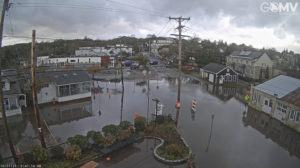
The 5 Corners area of Vineyard Haven flooded after a storm in 2021.
gomv.com/CWN
VINEYARD HAVEN – A Center for Coastal Studies mapping project was recently completed and revealed low-lying roads throughout Martha’s Vineyard that are vulnerable to flooding.
Coastal geologist and director of the Center’s seafloor mapping program Mark Borrelli recently completed work on the Storm Tide Pathways project.
The coastal sea level rise study identified over 700 places on the Vineyard where water will cause flooding during a storm.
Borrelli said the study discovered 47 Storm Tide Pathways that were a foot above the last storm of record, which was the hurricane of 1938.
“That means there are 47 different places that have never been flooded before that will flood if the total water level is only a foot higher than it was during that last storm of record,” Borrelli said.
He said the metric of the storm of record plus 1 foot is used because it’s a likely range given sea level rise and intensifying storms.
Borrelli said the mapping data can be used for planning purposes. He noted that Provincetown has used the map to anticipate which areas need to be prioritized when severe weather hits and helps the town in taking preventive measures.
“They’re getting ready for it. So, if there’s the worst-case scenario, they won’t be surprised,” he said.
The Pathways project data has also been used to create an app that helps first responders and homeowners plan for flooding before intense storms.
In a recent Sunday Journal interview, Borrelli said that the study took two years to complete.
The first year was dedicated to determining what areas were at risk of flooding. The second year was spent coordinating with the Vineyard Commission, first responders, and the DPW, focusing on roads and evacuation routes.
The Storm Tide Pathways map can be found here. Borrelli expects the data for the Vineyard should be available on the website later in August.
A presentation on the Pathways project will be given on Wednesday August 3 from 4pm to 6pm at the Sail Camp Park, 177 Barnes Road, Vineyard Haven.
Register for the free event through the Center for Coastal Studies.
By Brian Engles, CapeCod.com NewsCenter


