National Weather Service
HYANNIS – Barnstable County safety officials said that they are prepared ahead of the Nor’easter storm impacting Massachusetts today and tomorrow.
After a meeting this morning between first responders, emergency managers, elected officials and other regional partners, the county issued the following statement on expected storm conditions, as well as how residents can stay prepared:
OVERVIEW OF STORM
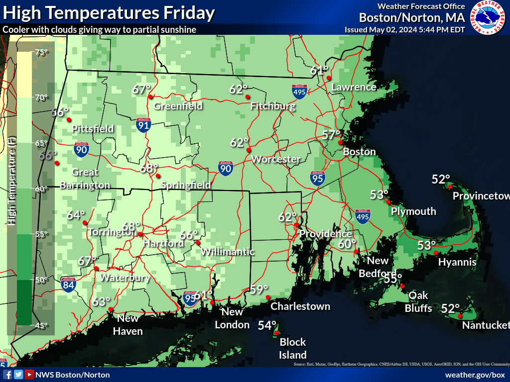
Winds are expected to increase across the Cape and Islands Tuesday into Wednesday night. The strongest winds are forecasted to begin between 2 – 3:00 PM on Tuesday into Wednesday with windy conditions expected to ease later Wednesday.
- Sustained winds along the east coast are expected to range from 30- 45 mph, and 40- 55 mph on the Cape Cod and the Islands.
- Maximum wind gusts on the east coast are expected to range from 50- 70mph, and 60- 75 mph on Cape Cod and the Islands.
Periods of moderate to heavy rain are expected to continue. Rainfall totals through Wednesday are expected to be 2 to 4 inches with localized amounts of 3-5 inches. Rain will transition to lighter rain with occasional showers for Wednesday morning then diminish to isolated showers and finally end Wednesday afternoon.
Minor coastal flooding is a concern for eastern MA during the high tide cycle Tuesday morning and late afternoon Wednesday. The greatest risk for beach erosion is expected Tuesday afternoon into early Wednesday.
The storm is expected to move offshore later Wednesday, and drier weather is expected Thursday.
PREPARATIONS UNDERWAY
- Eversource, National Grid and Verizon are prepared for the storm and have secured additional external crews on the Cape and Islands able to handle storm related damage.
- The Barnstable County Multi-Agency Coordination Center (MACC) will be activated at 4:00 PM today and will be ready to help towns and local agencies with resources, information, and regional coordination during the storm. Representatives from Eversource, Massachusetts Emergency Management Agency (MEMA), Department of Conservation and Recreation (DCR), Health and Medical Coordinating Coalitions (HMCC), and Meteorologist Frank O’Laughlin will be present.
- Shelters are in stand-by status. BCREPC will reassess the need for regional shelters during the storm and if needed will activate post-impact (after the storm passes). Note: there are 6 regional shelters in our region, and a map is available on bcrepc.org
The public is strongly encouraged to prepare accordingly for the potential effects of this storm.
- Safety and preparedness tips for nor’easters and coastal storms: https://www.mass.gov/info-details/noreaster-coastal-storm-safety-tips
- Power outage preparedness and safety information:
https://www.mass.gov/info-details/power-outage-safety-tips- Flood safety tips:
https://www.mass.gov/info-details/flood-safety-tips- Personal preparedness tips and additional storm preparedness resources are provided at www.bcrepc.org.
As a reminder, if you are experiencing a power outage, contact Eversource directly. Call 800-592-2000.