Strong storms are moving through the Cape. Scroll down this article for warnings and weather coverage:
This storm has moved out of the area:
Severe Thunderstorm Warning

BULLETIN – IMMEDIATE BROADCAST REQUESTED
Severe Thunderstorm Warning
National Weather Service Boston/Norton MA
810 PM EDT Wed May 8 2024
The National Weather Service in Boston/Norton has issued a
* Severe Thunderstorm Warning for…
Southwestern Barnstable County in southeastern Massachusetts…
South central Plymouth County in southeastern Massachusetts…
Southeastern Bristol County in southeastern Massachusetts…
* Until 900 PM EDT.
* At 809 PM EDT, a severe thunderstorm was located near Fairhaven, or 9 miles south of Marion, moving east at 35 mph.
HAZARD…Ping pong ball size hail.
SOURCE…Radar indicated.
IMPACT…People and animals outdoors will be injured. Expect damage to roofs, siding, windows, and vehicles.
* Locations impacted include…
Barnstable, Falmouth, Marion, Tisbury, Yarmouth, Wareham, Sandwich, Bourne, Fairhaven, Dennis, Mashpee, Mattapoisett, Rochester, Gosnold, and Hyannis.

Doppler radar shows hail cores approaching the Upper Cape
8:05 PM A new storm is approaching Truro. Doppler radar reports large hail. A marine warning has been issued:
7:15 PM: Wellfleet Police report Route 6 barely passable due to flooding.
We have confirmation of hail in Wellfleet via this video from Lisa King:
we050824a hail from Cape Wide News LLC on Vimeo.
This storm has moved out of the area. CWN is tracking more storms to our west.

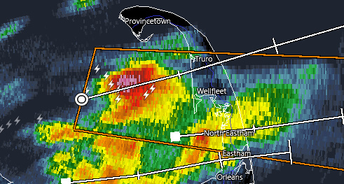
Doppler radar showing hail cores in Wellfleet and Eastham
Severe Thunderstorm Warning
BULLETIN – IMMEDIATE BROADCAST REQUESTED
Severe Thunderstorm Warning
National Weather Service Boston/Norton MA
645 PM EDT Wed May 8 2024
The National Weather Service in Boston/Norton has issued a
* Severe Thunderstorm Warning for…
Northeastern Barnstable County in southeastern Massachusetts…
* Until 715 PM EDT.
* At 645 PM EDT, a severe thunderstorm was located near Wellfleet, or 9 miles north of Brewster, moving east at 30 mph.
HAZARD…Quarter size hail.
SOURCE…Radar indicated.
IMPACT…Damage to vehicles is expected.
* Locations impacted include…
Orleans, Eastham, Wellfleet, and Truro.
PRECAUTIONARY/PREPAREDNESS ACTIONS…
For your protection move to an interior room on the lowest floor of a
building.