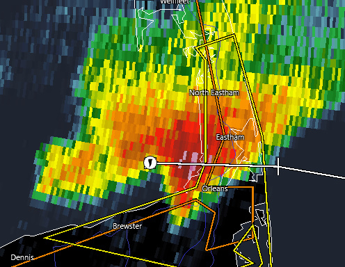
EASTHAM – Severe thunderstorm warnings were issued for parts of the Cape late Thursday afternoon. The strongest storm appeared to affect the Eastham and Orleans region. Marine warnings indicated waterspouts were possible over Cape Cod Bay. Radar also indicated the potential for hail up to 1.5 inches in diameter. As of 7 PM no reports of any damage had been received.
________________
Previous coverage:
The National Weather Service in Boston/Norton has issued a
* Severe Thunderstorm Warning for…
East central Barnstable County in southeastern Massachusetts…
* Until 730 PM EDT.
* At 624 PM EDT, a severe thunderstorm was located near Brewster, moving east at 35 mph.
HAZARD…60 mph wind gusts and quarter size hail.
SOURCE…Radar indicated.
IMPACT…Expect wind damage to trees and power lines. Minor hail damage to vehicles is possible.
* Locations impacted include…
Brewster, Dennis, Harwich, Orleans, Eastham and Wellfleet.
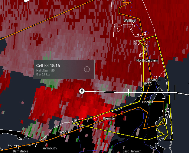
Doppler radar in Velocity Mode does show some rotation.
The National Weather Service in Boston/Norton has issued a
* Special Marine Warning for…
Cape Cod Bay…
Nantucket Sound…
* Until 645 PM EDT.
* At 603 PM EDT, a severe thunderstorm capable of producing waterspouts was located near Cape Cod Bay, moving east at 25 knots.
HAZARD…Waterspouts, wind gusts to 40 knots, and small hail.
SOURCE…Radar.
IMPACT…Waterspouts can easily overturn boats and create locally hazardous seas. Small craft could be damaged in briefly higher winds and suddenly higher waves.
* Locations impacted include…
Wellfleet Harbor, Cape Cod Bay, Barnstable Harbor and North Eastham.
Special Weather Statement
Special Weather Statement
National Weather Service Boston/Norton MA
526 PM EDT Thu Jul 14 2022
…A strong thunderstorm will impact portions of northwestern Barnstable and southeastern Plymouth Counties through 630 PM EDT…
At 525 PM EDT, Doppler radar was tracking a strong thunderstorm near Kingston, or near Plymouth, moving east at 40 mph.
HAZARD…Winds in excess of 40 mph and pea size hail.
SOURCE…Radar indicated.
IMPACT…Strong winds could cause minor damage such as downed branches. Little to no impact from hail is expected.
Locations impacted include…
Plymouth, Marshfield, Middleborough, Wareham, Bourne, Pembroke, Duxbury, East Bridgewater, Kingston, Carver, Hanson, Halifax and Plympton.
PRECAUTIONARY/PREPAREDNESS ACTIONS…
Get indoors when you hear thunder. Do not resume outdoor activities until at least 30 minutes after the storm has passed.
Frequent cloud to ground lightning is occurring with this storm. Lightning can strike 10 miles away from a thunderstorm. For your safety, go indoors or to your vehicle.