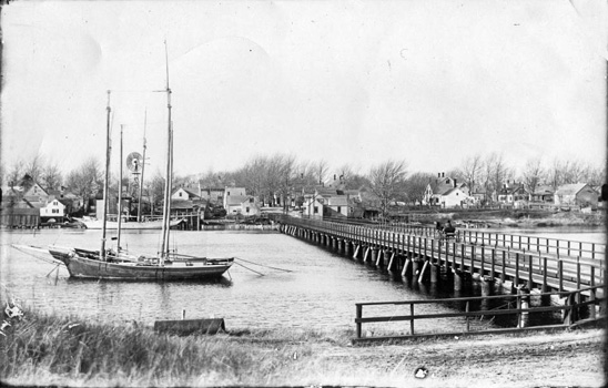
The original wooden bridge built in 1832, courtesy of the Dennis Historical Society
Cape Cod’s landscape is dotted with ponds, lakes, and rivers. All over the peninsula there are bridges crossing the rivers. The most well known Cape bridges are certainly the Sagamore and Bourne Bridges which connect the Cape to the mainland across the Cape Cod Canal. However those bridges were not always necessary as the canal is a manmade waterway. Long before the canal rivers still existed, including one which nearly bisects the Cape right in the middle. Bass River marks the unofficial middle of Cape Cod and this is the history of one of the bridges which crosses it.
There are two bridges which cross Bass River. One crosses at present-day Highbank Road near Wilbur Park, while the other connects Yarmouth to Dennis on Route 28. This is the much more traveled bridge. The idea of there not being a bridge crossing over the river may seem unbelievable in the 21st century, yet that was indeed a fact for a long period of Cape Cod history.
It was not until 1832 that the first request for a bridge to be built across the 560-foot wide span of Bass River came about. Levi Crowell among others submitted a proposal to the state Senate in February 1832 for a bridge to cross the river from Union Street in South Yarmouth to Ferry Street in West Dennis. Leading up to that time the only way to cross Bass River at that spot was by ferry. On March 2, 1832 the Senate agreed and the bridge was approved.
What would come to be known as the Bass River Lower Bridge (the Upper Bridge being the one on Highbank Road) was built of wood with a small drawbridge in the center allowing vessels to pass through. The bridges made travel between Yarmouth and Dennis, and throughout the Cape easier. People and horse drawn buggies could safely pass over the water while modest-sized boats could continue to navigate up the river. That convenience did not come without a price though.
In the years before the bridge was constructed and ferry service was the way to cross Bass River a toll needed to be paid to do so. Naturally when the bridge was opened the toll remained. This stayed the case until 1869 when a petition was spearheaded by Russell Farris of South Yarmouth to abolish the toll on the bridge. The battle raged locally and eventually made its way to the Supreme Court. In May 1870 the courts ruled that both Bass River Bridges were public highways and therefore free to travel.
In 1888 due to its proximity on the peninsula an idea was floated to create a Cape Cod Canal using Bass River. Thomas Bacon petitioned the Committee on Harbors and Public Lands to look into the idea. His proposal suggested the canal path would travel along Bass River, flowing into Follins Pond, and out through Gray’s Beach, necessitating the digging of a mile and half connection. Bacon surmised the project would cost $2.5 million ($62.5 million in 2017), and was a natural fit with the exit through Gray’s Beach creating a logical path to Boston. The project did not make it much further than the planning stages and it would be a quarter-century until the Cape Cod Canal became reality.
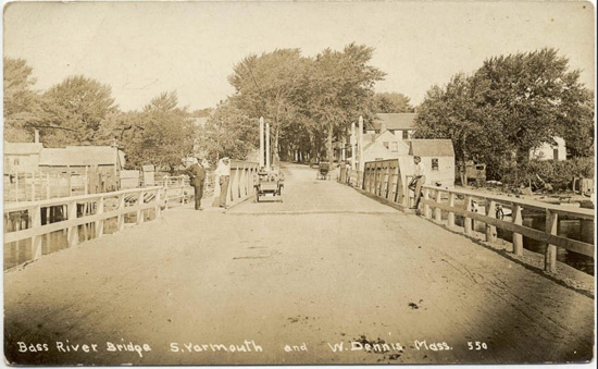
The third bridge across the river, built in 1907, courtesy of the Dennis Historical Society
In February 1891 a vote was taken by Yarmouth and Dennis residents to approve the possibility of constructing a new Bass River Lower Bridge. Preliminary surveying actually took place that July with the new bridge estimated to cost $10,000 ($258,000 in 2017). The new bridge would be built in the fall of 1891 into the beginning of 1892. However besides improving the road leading to it in 1895 the new bridge would not leave much of a mark, having the shortest reign as it fell rapidly into disrepair.
In 1907 a third Bass River Bridge would become a reality. This bridge was unique as it came complete with a manmade island. The bridge would have an earthen mound in its center, perhaps signifying the border between Yarmouth and Dennis. The Yarmouth side of the bridge would be larger, containing a drawbridge to allow boats to pass through while the Dennis side was smaller. Those who managed the drawbridge in the day made an average salary of $25 per year.
The increased availability of the automobile during the first few decades of the 20th century caused trouble on the bridge. Its width was not properly accommodating for auto travel and many accidents would occur in the decades after the bridge’s opening. Plans came about for a fourth Bass River Bridge. By the end of 1933 surveys were being conducted by the county commissioners about the feasibility of a wider bridge to accommodate auto travel. On August 16, 1934 plans for the new bridge were approved by the War Department.
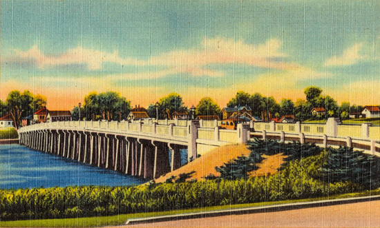
The fourth, and current bridge, built in 1935, courtesy of the Dennis Historical Society
The concrete bridge was to cost $200,000 ($3.6 million in 2017), stretching 600 feet long and 40 feet wide with both Dennis and Yarmouth sharing the expenses for streetlights along the structure. Work began fast and furiously in December 1934 with pedestrians being allowed to cross but vehicles being diverted. More than 120 mainly local men worked on the bridge and although it fell slightly behind schedule the fourth Bass River Bridge opened to vehicles on July 3, 1935 in time for the holiday travel.
This fourth incarnation of the bridge connecting Yarmouth and Dennis has had its share of repairs but has held strong for more than eighty years. Still, nothing lasts forever and the time is winding down on this longest reigning Bass River Bridge. In the fall of 2020 construction will start on a fifth Bass River Bridge. According to the Massachusetts Department of Transportation the project is estimated to cost $17,250,000.
By Christopher Setterlund