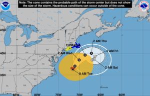
 HYANNIS – Cape Cod and the Islands will likely experience tropical storm conditions late today into tomorrow as Hurricane Jose passes to the south of New England.
By then, the disturbance will likely be a tropical storm with the characteristics of a Nor’ Easter.
At the height of the storm on Wednesday, the region can expect heavy rain and strong winds out of the northeast at 20 to 45 mph, with gusts to 60 mhp.
According to the National Hurricane Center in Miami, satellite images indicate that Jose was losing some tropical characteristics early Monday.
The storm should remain over warm Gulf Stream waters during the next 24 hours, but it will also be in an environment of strong south-southwesterly shear.
Unfavorable conditions should cause a slow weakening trend and lead to post-tropical transition.
Eversource said they were ready to respond to any power problems that may develop during the storm and the Barnstable County Regional Emergency Planning Committee was monitoring the track of Jose but had no immediate plans to open the regional shelter system.
“We continue to monitor Jose’s path very carefully and are ready to address any impacts to the electric system,” said Peter Clarke, Senior Vice President of Emergency Preparedness for Eversource.
“We’re confident our ongoing technology upgrades, combined with our tried and tested emergency response plan, will enable us to safely and efficiently handle any issues that may arise.”
Eversource crews assisting with power restoration in Florida after Hurricane Irma are returning home to Massachusetts and ready to respond to any power outages if needed. All other company employees are also on standby and prepared to assist with any potential storm restoration.
The Coast Guard was flying over the fishing grounds, sending radio messages to the fleet about the impending storm. They also asked anyone with small paddleboats and kayaks to make sure they were removed from shore so they wouldn’t drift away and prompt unneeded searches.
Minor to moderate coastal flooding is possible from Delaware to southern New England during the next several days.
The Barnstable County Regional Emergency Planning Committee has been monitoring the storm and will provide public advisories as needed. The committee plans on activating their Multi-Agency Coordination Center at 8 a.m. on Wednesday.
Nauset Beach South and Nauset Spit will close to all OSV use at 4:00 pm Tuesday. All vehicles on the beach will be asked to leave prior to 4:00 pm.
Conditions on the beach will be reassessed Wednesday morning and an update will be provided prior to 10:00 am.


