


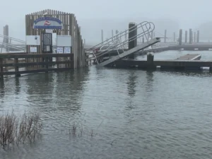
A partially-submerged walkway at Allen Harbor Yacht Club in Harwich Port after the Jan. 13th storm. Cover photo: Oyster Pond Rd. and Surf Dr. in Falmouth on Jan. 10th.
HYANNIS – Heavy rain-and-wind storms which hit Cape Cod earlier this month left a mark.
The state Office of Coastal Zone Management says it surveyed the region for the impacts of the storms which happened on January 10th and 13th. The survey team reportedly found widespread beach, dune and bank erosion along the Massachusetts coast. There was also damage done to docks and piers on the Cape and Nantucket.
The full assessment can be read on the Massachusetts Executive Office of Energy and Environmental Affairs website. EEA Secretary Rebecca Tepper thanked the storm team for its reports, which she says are “invaluable for assessing damage in real-time and for evaluating the long-term impacts of climate change and sea level rise on our shoreline.”
Winter has come more clearly into the picture this week, with one round of snow falling on Cape Cod Tuesday, which topped out at 2.8 inches in Barnstable. The National Weather Service is predicting up to three more inches on the Cape on Friday, and says the evening commute on Routes 3 and 6 could be affected.
By Jim McCabe, CapeCod.com NewsCenter


