This page is a summary of all severe weather warnings issued Saturday afternoon/evening for Cape Cod from most recent backwards.
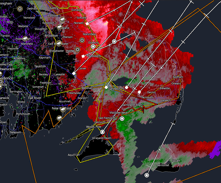
Dopler Radar velocity mode showing rotation in the upper Cape. (click image to enlarge)
Special Weather Statement
Special Weather Statement
National Weather Service Boston/Norton MA
649 PM EST Sat Nov 13 2021
MAZ022-140030-
Barnstable MA-
649 PM EST Sat Nov 13 2021
…A strong thunderstorm will impact portions of northeastern
Barnstable County through 730 PM EST…
At 648 PM EST, Doppler radar was tracking a strong thunderstorm over
Wellfleet, or 12 miles north of Brewster, moving northeast at 50 mph.
HAZARD…Winds in excess of 40 mph and pea size hail.
SOURCE…Radar indicated.
IMPACT…Strong winds could cause minor damage such as downed
branches. Little to no impact from hail is expected.
Locations impacted include…
Eastham, Wellfleet and Truro.
PRECAUTIONARY/PREPAREDNESS ACTIONS…
Get indoors when you hear thunder. Do not resume outdoor activities
until at least 30 minutes after the storm has passed.
Tornado Warning
BULLETIN – EAS ACTIVATION REQUESTED
Tornado Warning
National Weather Service Boston/Norton MA
627 PM EST Sat Nov 13 2021
The National Weather Service in Boston/Norton has issued a
* Tornado Warning for…
South central Barnstable County in southeastern Massachusetts…
* Until 700 PM EST.
* At 626 PM EST, a severe thunderstorm capable of producing a tornado
was located near Barnstable, moving northeast at 55 mph.
HAZARD…Tornado.
SOURCE…Radar indicated rotation.
IMPACT…Flying debris will be dangerous to those caught without
shelter. Mobile homes will be damaged or destroyed.
Damage to roofs, windows, and vehicles will occur. Tree
damage is likely.
* This dangerous storm will be near…
Yarmouth and Dennis around 630 PM EST.
Brewster around 640 PM EST.
Other locations impacted by this tornadic thunderstorm include
Hyannis.
PRECAUTIONARY/PREPAREDNESS ACTIONS…
TAKE COVER NOW! Move to a basement or an interior room on the lowest
floor of a sturdy building. Avoid windows. If you are outdoors, in a
mobile home, or in a vehicle, move to the closest substantial shelter
and protect yourself from flying debris.
Severe Weather Statement
National Weather Service Boston/Norton MA
617 PM EST Sat Nov 13 2021
…A TORNADO WARNING REMAINS IN EFFECT UNTIL 630 PM EST FOR SOUTH
CENTRAL BARNSTABLE COUNTY…
At 617 PM EST, a severe thunderstorm capable of producing a tornado
was located near Mashpee, or near Barnstable, moving northeast at 60
mph.
HAZARD…Tornado.
SOURCE…Radar indicated rotation.
IMPACT…Flying debris will be dangerous to those caught without
shelter. Mobile homes will be damaged or destroyed. Damage
to roofs, windows, and vehicles will occur. Tree damage is
likely.
This dangerous storm will be near…
Barnstable and Yarmouth around 625 PM EST.
Dennis around 630 PM EST.
Other locations impacted by this tornadic thunderstorm include
Hyannis.
PRECAUTIONARY/PREPAREDNESS ACTIONS…
TAKE COVER NOW! Move to a basement or an interior room on the lowest
floor of a sturdy building. Avoid windows. If you are outdoors, in a
mobile home, or in a vehicle, move to the closest substantial shelter
and protect yourself from flying debris.
Tornado Warning
Tornado Warning
BULLETIN – EAS ACTIVATION REQUESTED
Tornado Warning
National Weather Service Boston/Norton MA
607 PM EST Sat Nov 13 2021
The National Weather Service in Boston/Norton has issued a
* Tornado Warning for…
Northeastern Dukes County in southeastern Massachusetts…
South central Barnstable County in southeastern Massachusetts…
* Until 630 PM EST.
* At 607 PM EST, a severe thunderstorm capable of producing a tornado
was located over Oak Bluffs, moving northeast at 65 mph.
HAZARD…Tornado.
SOURCE…Radar indicated rotation.
IMPACT…Flying debris will be dangerous to those caught without
shelter. Mobile homes will be damaged or destroyed.
Damage to roofs, windows, and vehicles will occur. Tree
damage is likely.
* This dangerous storm will be near…
Mashpee around 620 PM EST.
Barnstable and Yarmouth around 625 PM EST.
Dennis around 630 PM EST.
Other locations impacted by this tornadic thunderstorm include
Hyannis.
PRECAUTIONARY/PREPAREDNESS ACTIONS…
TAKE COVER NOW! Move to a basement or an interior room on the lowest
floor of a sturdy building. Avoid windows. If you are outdoors, in a
mobile home, or in a vehicle, move to the closest substantial shelter
and protect yourself from flying debris.
BULLETIN – EAS ACTIVATION REQUESTED
Tornado Warning
National Weather Service Boston/Norton MA
547 PM EST Sat Nov 13 2021
The National Weather Service in Boston/Norton has issued a
* Tornado Warning for…
Dukes County in southeastern Massachusetts…
* Until 615 PM EST.
* At 547 PM EST, a severe thunderstorm capable of producing a tornado
was located over Aquinnah, moving northeast at 45 mph.
HAZARD…Tornado.
SOURCE…Radar indicated rotation.
IMPACT…Flying debris will be dangerous to those caught without
shelter. Mobile homes will be damaged or destroyed.
Damage to roofs, windows, and vehicles will occur. Tree
damage is likely.
* This dangerous storm will be near…
West Tisbury around 605 PM EST.
Oak Bluffs and Tisbury around 610 PM EST.
PRECAUTIONARY/PREPAREDNESS ACTIONS…
TAKE COVER NOW! Move to a basement or an interior room on the lowest
floor of a sturdy building. Avoid windows. If you are outdoors, in a
mobile home, or in a vehicle, move to the closest substantial shelter
and protect yourself from flying debris.
Severe Thunderstorm Warning
BULLETIN – IMMEDIATE BROADCAST REQUESTED
Severe Thunderstorm Warning
National Weather Service Boston/Norton MA
545 PM EST Sat Nov 13 2021
The National Weather Service in Boston/Norton has issued a
* Severe Thunderstorm Warning for…
Dukes County in southeastern Massachusetts…
Southwestern Barnstable County in southeastern Massachusetts…
Southeastern Plymouth County in southeastern Massachusetts…
* Until 645 PM EST.
* At 545 PM EST, a severe thunderstorm was located over Aquinnah,
moving northeast at 50 mph.
HAZARD…60 mph wind gusts.
SOURCE…Radar indicated.
IMPACT…Expect damage to trees and power lines.
* Locations impacted include…
Plymouth, Barnstable, Falmouth, Oak Bluffs, Edgartown, Tisbury,
Aquinnah, Yarmouth, Sandwich, Bourne, Mashpee, West Tisbury,
Chilmark, Gosnold and Hyannis.
PRECAUTIONARY/PREPAREDNESS ACTIONS…
For your protection move to an interior room on the lowest floor of a
building.