


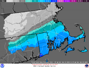
 HYANNIS – Cape Cod’s first significant blast of winter weather this season could deliver 6-to-10 inches of snow across the area.
A blizzard warning is in effect for Barnstable, Dukes and Nantucket Counties.
Snow began spreading across the region by midday Saturday and is expected to continue into the evening and overnight hours. Forecasters predict 3-to-5 inches will fall by late in the day, with possibly another 3-to-5 by early Sunday morning, when the snow will finally come to an end.
Winds blowing out of the northeast of 25-35 mph throughout the storm could cause some problems with downs trees and scattered power outages. Gusts could be as high as 49 mph.
National Weather Service Meteorologist Rebecca Gould the high winds could make the roadways dangerous.
“It’s going to be very difficult to drive, especially on the Cape and Islands and along the south coast with the high winds, that’s going to limit visibility as well as make it challenging to drive,” said Gould.
High wind warnings and coastal flood watches have also been issued by the National Weather Service. The storm should move away by Sunday, leaving partly sunny skies.
The storm isn’t expected to be as big as Winter Storm Juno that hit the Cape and Islands last year, but Gould said people should still be prepared.
“It’s a typical New England Nor’easter that happens in the winter, but we haven’t had very much snow this year, so it is something to be concerned about as we all get our bearings again with winter and remember how to drive in the snow,” said Gould.
The Barnstable County Regional Emergency Planning Committee met on Friday afternoon and decided not to activate the regional shelter system at this time, but will continue to monitor the forecast for any changes.
Officials did advise residents to refrain from driving during the storm to allow highway crews to treat and clear the roads.
Eversource Energy said they are prepared for the storm.
“We prepare year-round for storms like this and are ready to address any damage to the electric system,” said Peter Clarke, Senior Vice President of Emergency Preparedness for Eversource. “While we may not be able to control the weather in New England, we know that our ongoing system improvements are helping us to better handle whatever Mother Nature throws at us.”
If conditions warrant, the Town of Barnstable will re-activate the Storm Alert feature on their website (www.townofbarnstable.us) which shares actual road plowing activities by the Department of Public Works. They also have a new storm line (508-862-4636) that will be updated with that same information.
The Steamship Authority and Hy-Line cancelled all service between Hyannis and Nantucket until Sunday morning. Steamship service between Woods Hole and Martha’s Vineyard was also cancelled until Sunday.
The Town of Dennis has implemented a parking ban from 8 a.m. Saturday until 8 a.m. Monday. Vehicles parked on roadways may be towed at owner’s expense. Wareham also implemented a parking ban until further notice.
The Barnstable Municipal Airport suspended all air service at 2:20 p.m. Saturday.
Strong winds and mild to moderate coastal flooding associated with this storm are likely across portions of Eastern Massachusetts Saturday and Sunday. High astronomical tides will combine with strong onshore Northeast winds to yield a risk for minor to perhaps pockets of moderate coastal flooding.
The same storm began hammering the mid-Atlantic and Southern states in the overnight and early morning hours Saturday.
Kentucky State Police say emergency shelters are being opened near two exits along Interstate 75 for motorists who’ve been stranded by a mammoth storm that’s already dumped 18 inches of snow on portions of the state.
State Police officials tell Kentucky television station WTVQ that southbound traffic was being diverted to Exit 76 in Berea, while northbound traffic was being diverted to Exit 41 in London.
A section of I-75 in Rockcastle County was closed twice during Friday afternoon and evening due to numerous accidents. It turned I-75 in both directions in Rockcastle and Laurel counties into a parking lot. Some motorists said they had been stuck on I-75 for 10 hours. The American Red Cross was providing food to stranded drivers.
The National Weather Service’s website says blizzard warnings remained in effect Saturday for eastern and coastal portions of the mid-Atlantic, from mountain areas in Virginia to Washington, D.C., Philadelphia, New York City and Long Island, New York.
Winter storm warnings and winter weather advisories also remained in effect for a large area that extended from the Tennessee Valley to the Ohio Valley, and spanned from the Carolinas to southern New England. High wind warnings and watches are in effect for coastal regions in the mid-Atlantic and southern New England. Coastal flood warnings and watches are in effect from Virginia to Massachusetts.
Storm and gale warnings are in effect for mid-Atlantic and New England Coastal waters.
The Weather service says 7 inches of snow fell in Washington, D.C. while snowfall amounts in nearby Maryland ranged between 4.5 inches in Baltimore and 13.5 inches in Oakland. In Virginia, Reagan National Airport reported 6.8 inches of snow and Elma had 15 inches. Other states that recorded snowfall amounts greater than 6 inches included Delaware, Georgia, North Carolina, New Jersey, Ohio, Pennsylvania, South Carolina, Tennessee and West Virginia. Various locations in Georgia and Alabama received between 1 and 3.5 inches of snow.
Officials say the snowstorm has delayed the return of a cruise ship to Port of Baltimore.
The Maryland Department of Transportation says in a statement that the port’s cargo terminals will be closed through Sunday. The Royal Caribbean International ship Grandeur of the Seas was scheduled to dock Sunday morning but will arrive Monday morning instead.
Its next cruise had been scheduled to depart Sunday afternoon.
Royal Caribbean didn’t immediately return calls and emails.
Passenger Meg Ryan of Hamilton, New Jersey, says in an email to The Associated Press that she’s happy to be delayed not only because it’s an extra vacation but because safety comes first and travel Sunday would be difficult if not impossible. She says some passengers were having trouble rebooking transportation from Baltimore to their homes.
By MATT PITTA, CapeCod.com NewsCenter, with material from The Associated Press


Speak Your Mind