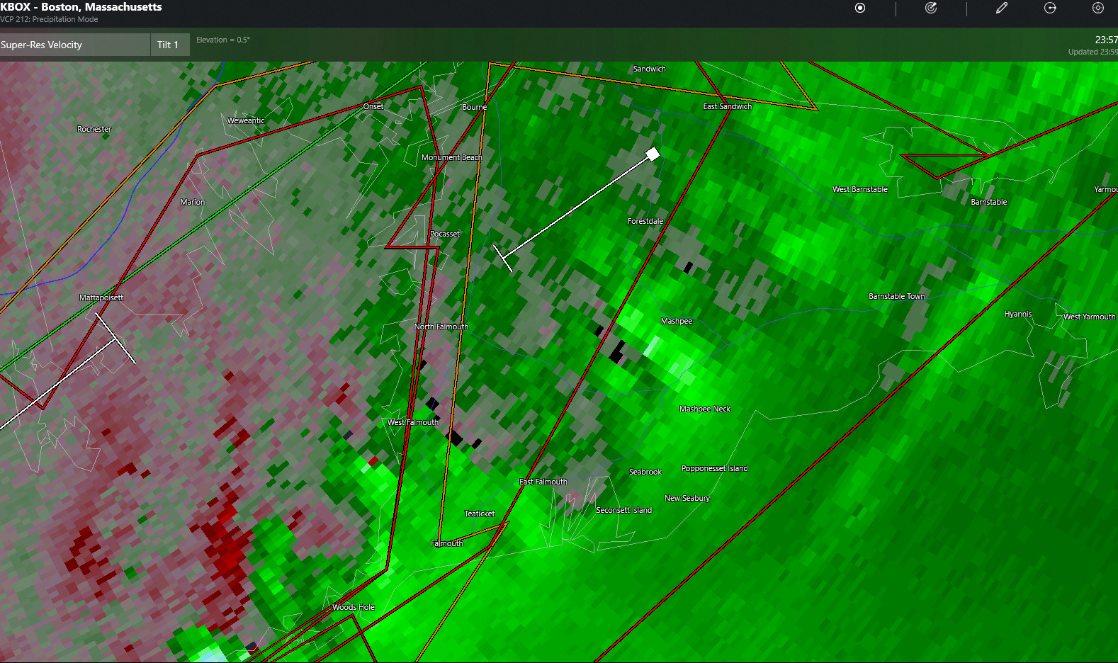
Doppler radar in velocity mode showing rotation over Falmouth (click image to enlarge)
Flood Warning
Flood Warning
National Weather Service Boston/Norton MA
754 AM EDT Thu Sep 2 2021
The National Weather Service in Norton has issued a
* Flood Warning for…
Barnstable County in southeastern Massachusetts…
Northeastern Dukes County in southeastern Massachusetts…
Southeastern Plymouth County in southeastern Massachusetts…
* Until 145 PM EDT.
* At 754 AM EDT, Doppler radar and rain gauge reports indicated
heavy rain had fallen in the warning area. Between 3 and 6 inches
of rain have fallen. Urban and poor drainage flooding lingered as
a result of this heavy rainfall.
* Significant urban and poor drainage flooding will linger this
morning, and may take some time to fully recede. Heed any road
closures.
* Some locations that will experience flooding include…
Plymouth, Barnstable, Falmouth, Brewster, Marion, Yarmouth,
Middleborough, Wareham, Sandwich, Bourne, Dennis, Mashpee,
Harwich, Carver, Chatham, Orleans, Rochester, Gosnold and Hyannis.
PRECAUTIONARY/PREPAREDNESS ACTIONS…
Turn around, don`t drown when encountering flooded roads. Most flood
deaths occur in vehicles.
(Expired)…A TORNADO WARNING REMAINS IN EFFECT UNTIL 245 AM EDT FOR EAST
CENTRAL BARNSTABLE COUNTY…
At 213 AM EDT, a severe thunderstorm capable of producing a tornado
was located over Dennis, or near Brewster, moving northeast at 40
mph.
HAZARD…Tornado.
SOURCE…Radar indicated rotation.
IMPACT…Flying debris will be dangerous to those caught without
shelter. Mobile homes will be damaged or destroyed. Damage
to roofs, windows, and vehicles will occur. Tree damage is
likely.
This dangerous storm will be near…
Brewster around 220 AM EDT.
PRECAUTIONARY/PREPAREDNESS ACTIONS…
TAKE COVER NOW! Move to a basement or an interior room on the lowest
floor of a sturdy building. Avoid windows. If you are outdoors, in a
mobile home, or in a vehicle, move to the closest substantial shelter
and protect yourself from flying debris.
Heavy rainfall may hide this tornado. Do not wait to see or hear the
tornado. TAKE COVER NOW!
Tornadoes are extremely difficult to see and confirm at night. Do not
wait to see or hear the tornado. TAKE COVER NOW!
(Expired)…A TORNADO WARNING REMAINS IN EFFECT UNTIL 145 AM EDT FOR
SOUTHWESTERN BARNSTABLE AND DUKES COUNTIES…
At 118 AM EDT, a severe thunderstorm capable of producing a tornado
was located 7 miles northwest of Dennis, or 9 miles northeast of
Barnstable, moving northeast at 35 mph.
HAZARD…Tornado.
SOURCE…Radar indicated rotation.
IMPACT…Flying debris will be dangerous to those caught without
shelter. Mobile homes will be damaged or destroyed. Damage
to roofs, windows, and vehicles will occur. Tree damage is
likely.
This tornadic thunderstorm will remain over mainly rural areas of
SOUTHWESTERN BARNSTABLE AND DUKES COUNTIES, including the following
locations… Hyannis.
PRECAUTIONARY/PREPAREDNESS ACTIONS…
TAKE COVER NOW! Move to a basement or an interior room on the lowest
floor of a sturdy building. Avoid windows. If you are outdoors, in a
mobile home, or in a vehicle, move to the closest substantial shelter
and protect yourself from flying debris.
Heavy rainfall may hide this tornado. Do not wait to see or hear the
tornado. TAKE COVER NOW!
…FLASH FLOOD WARNING REMAINS IN EFFECT UNTIL 8 AM EDT THIS MORNING
FOR BARNSTABLE AND DUKES COUNTIES…
At 137 AM EDT, Trained weather spotters reported thunderstorms
producing heavy rain across the warned area. Between 2 and 4 inches
of rain have fallen. Additional rainfall amounts of 1 to 3 inches
are possible in the warned area. Flash flooding is ongoing or
expected to begin shortly.
HAZARD…Flash flooding caused by thunderstorms.
SOURCE…Trained spotters reported.
IMPACT…Flash flooding of small creeks and streams, urban areas,
highways, streets and underpasses as well as other poor
drainage and low-lying areas.
Some locations that will experience flash flooding include…
Barnstable, Falmouth, Brewster, Marion, Oak Bluffs, Edgartown,
Tisbury, Aquinnah, Yarmouth, Wareham, Sandwich, Bourne, Dennis,
Mashpee, West Tisbury, Chilmark, Gosnold and Hyannis.
At 1218 AM in New Bedford…West Rodney Boulevard from 160 West
Rodney Boulevard to Aquidneck street is closed due to flooding with
water going across the road like a river. Cove Road closed from
Stapleton to County Street. A few flooded basements have also been
reported in New Bedford.
PRECAUTIONARY/PREPAREDNESS ACTIONS…
Be especially cautious at night when it is harder to recognize the
dangers of flooding.
(Expired) The National Weather Service in Boston/Norton has issued a
* Tornado Warning for…
North central Dukes County in southeastern Massachusetts…
Northwestern Barnstable County in southeastern Massachusetts…
* Until 1245 AM EDT.
* At 1156 PM EDT, a severe thunderstorm capable of producing a
tornado was located near Gosnold, or 7 miles west of Tisbury,
moving northeast at 40 mph.
HAZARD…Tornado.
SOURCE…Radar indicated rotation.
IMPACT…Flying debris will be dangerous to those caught without
shelter. Mobile homes will be damaged or destroyed.
Damage to roofs, windows, and vehicles will occur. Tree
damage is likely.
* This dangerous storm will be near…
Tisbury around 1200 AM EDT.
Falmouth around 1215 AM EDT.
Mashpee around 1225 AM EDT.
Sandwich and Bourne around 1230 AM EDT.
Barnstable around 1235 AM EDT.
PRECAUTIONARY/PREPAREDNESS ACTIONS…
TAKE COVER NOW! Move to a basement or an interior room on the lowest
floor of a sturdy building. Avoid windows. If you are outdoors, in a
mobile home, or in a vehicle, move to the closest substantial shelter
and protect yourself from flying debris.
Heavy rainfall may hide this tornado. Do not wait to see or hear the
tornado. TAKE COVER NOW!
Tornadoes are extremely difficult to see and confirm at night. Do not
wait to see or hear the tornado. TAKE COVER NOW!
(Expired)…A TORNADO WARNING REMAINS IN EFFECT UNTIL 1215 AM EDT FOR NORTH
CENTRAL DUKES…SOUTHWESTERN BARNSTABLE…SOUTHEASTERN PLYMOUTH AND
SOUTHEASTERN BRISTOL COUNTIES…
At 1142 PM EDT, a severe thunderstorm capable of producing a tornado
was located over Gosnold, or 7 miles southeast of Dartmouth, moving
northeast at 40 mph.
HAZARD…Tornado.
SOURCE…Radar indicated rotation.
IMPACT…Flying debris will be dangerous to those caught without
shelter. Mobile homes will be damaged or destroyed. Damage
to roofs, windows, and vehicles will occur. Tree damage is
likely.
This dangerous storm will be near…
New Bedford and Fairhaven around 1155 PM EDT.
Mattapoisett around 1200 AM EDT.
Marion around 1205 AM EDT.
Falmouth around 1210 AM EDT.
Wareham and Rochester around 1215 AM EDT.
Bourne around 1220 AM EDT.
Sandwich around 1225 AM EDT.
PRECAUTIONARY/PREPAREDNESS ACTIONS…
TAKE COVER NOW! Move to a basement or an interior room on the lowest
floor of a sturdy building. Avoid windows. If you are outdoors, in a
mobile home, or in a vehicle, move to the closest substantial shelter
and protect yourself from flying debris.
Heavy rainfall may hide this tornado. Do not wait to see or hear the
tornado. TAKE COVER NOW!
Torrential rainfall is occurring with this storm, and may lead to
flash flooding. Do not drive your vehicle through flooded roadways.