Wind Advisory
URGENT – WEATHER MESSAGE
National Weather Service Boston/Norton MA
345 AM EDT Sat Mar 23 2024
…WIND ADVISORY IN EFFECT FROM 5 PM THIS AFTERNOON TO 11 PM EDT THIS EVENING…
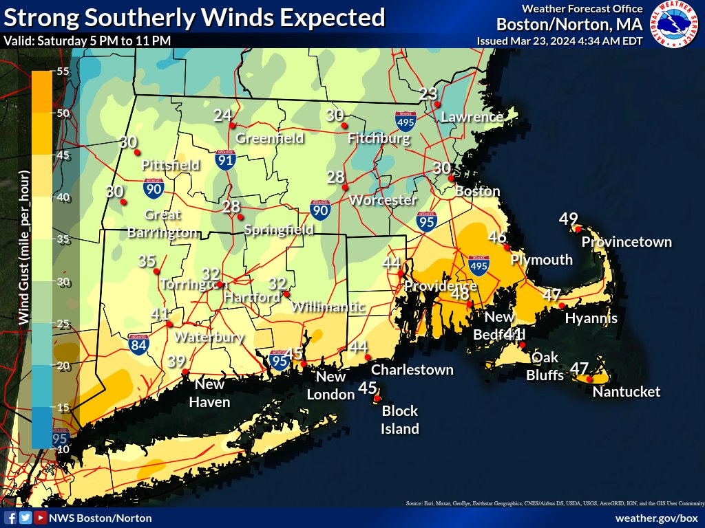
* WHAT…South winds 20 to 30 mph with gusts up to 50 mph expected.
* WHERE…Portions of southeastern Massachusetts and northern and southern Rhode Island.
* WHEN…From 5 PM this afternoon to 11 PM EDT this evening.
* IMPACTS…Gusty winds will blow around unsecured objects. Tree limbs could be blown down and a few power outages may result.
PRECAUTIONARY/PREPAREDNESS ACTIONS…
Winds this strong can make driving difficult, especially for high profile vehicles. Use extra caution.
Flood Watch
Flood Watch
National Weather Service Boston/Norton MA
348 AM EDT Sat Mar 23 2024
…FLOOD WATCH REMAINS IN EFFECT FROM 8 AM EDT THIS MORNING THROUGH SUNDAY MORNING…
* WHAT…Flooding caused by excessive rainfall continues to be possible.
* WHERE…Portions of northern Connecticut, including the following areas, Hartford CT, Tolland CT and Windham CT, Massachusetts, including the following areas, Barnstable MA, Central Middlesex MA, Dukes MA, Eastern Essex MA, Eastern Hampden MA, Eastern Norfolk MA, Eastern Plymouth MA, Nantucket MA, Northern Bristol MA, Southeast Middlesex MA, Southern Bristol MA, Southern Plymouth MA, Southern Worcester MA, Suffolk MA, Western Essex MA, Western Hampden MA, Western Norfolk MA and Western Plymouth MA, and Rhode Island, including the following areas, Block Island RI, Bristol RI, Eastern Kent RI, Newport RI, Northwest Providence RI, Southeast Providence RI, Washington RI and Western Kent RI.
* WHEN…From 8 AM EDT this morning through Sunday morning.
* IMPACTS…Excessive runoff may result in flooding of rivers, creeks, streams, and other low-lying and flood-prone locations. Creeks and streams may rise out of their banks. Flooding may occur in poor drainage and urban areas.
* ADDITIONAL DETAILS…
– Two to three inches of rainfall with locally higher amounts are expected today into tonight. The heaviest rain will occur this afternoon and evening which may lead to urban and poor drainage street flooding as well as sharp rises on rivers and streams. Some river flooding is expected.
– http://www.weather.gov/safety/flood
PRECAUTIONARY/PREPAREDNESS ACTIONS…
You should monitor later forecasts and be alert for possible Flood Warnings. Those living in areas prone to flooding should be prepared to take action should flooding develop.