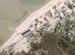
Photo Courtesy: GOOGLE Earth
DENNIS – Earlier this year, the Cape Cod Commission was awarded funding from NOAA to conduct public outreach on coastal resilience.
As part of this process, the Cape Cod Commission and the Town of Dennis are collecting images of coastal assets that are vulnerable to erosion.
The UAV will be flown from the intersection of Taunton Ave/Dr. Bottero Road to Chase Garden Creek and it will gather aerial imagery along the coastline and marsh. Dr. Bottero Road undergoes severe erosion each year as a result of winter storms and the town and regional stakeholders are interested in gathering current topographic information, before any winter storms in 2016 and 2017.
This dataset will be used in the public outreach process for the NOAA grant and serve as a baseline for future impacts from coastal storms. The small UAV will capture oblique images of the coastline and video. Any identifiable people will be digitized out during editing of the raw dataset. AirShark, a certified commercial operator, will fly the UAV with a certified FAA pilot and visual observer.
The small UAV will be flown at 200-400 feet above ground and operations will have the required authorizations from the FAA, State and Local entities before the flight. The UAV will be flown over the beach and ocean and personnel will have signs, radios and safety vests during the flight. The flight will be conducted between November 20th and December 9th depending on the weather.
For more information – Any questions may be directed to David Johansen, Director of Public Works, Dennis, MA 508-760-6220
Information provided by Dennis Police