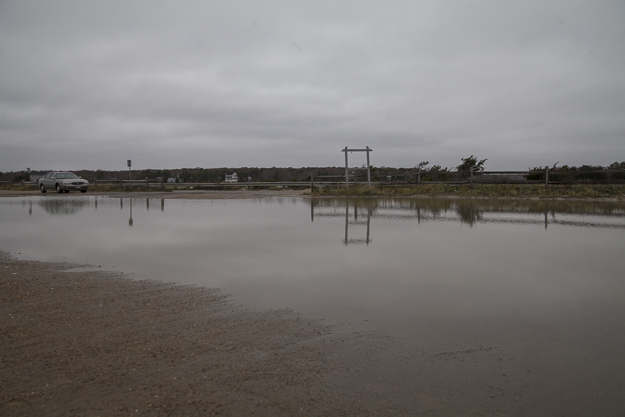
FALMOUTH – The extent of a vulnerability study currently underway in Falmouth was presented to selectmen last month as the town looks to address potential coastal hazards posed by natural disasters.
The study will assess the risks to infrastructure and properties along the town’s coastline from severe storms, coastal erosion, and a rising sea level.
The Woods Hole Group is conducting the study, which will evaluate areas of the town up to 26.2 feet (8 meters) above sea level.
Elise Leduc, a scientist with the Woods Hole Group, previewed the study for selectmen in the early-December meeting. She says the study will provide data of future coastal flooding scenarios and identify potential flooding impacts to town-owned infrastructure.
“This project is going to focus on town assets only, with the exception of roads. We are including all of the roads that are within our model grid,” Leduc explained.
“This will also look at not just infrastructure, buildings, and man-made things, but sea level rise impacts to natural resources as well: beaches, marshes, coastlines.”
Leduc says the study is currently in its first phase, where scientists will locate key properties and buildings in between the coastline and the 26.2-foot elevation. Phase one will also identify the point at which the water level will cause severe damage to areas under evaluation.
“Phase Two is really taking those assets and our results and doing a vulnerability assessment, and seeing how the flood risks and the assets overlay with each other, and then prioritizing those based on risk and coming up with strategies and ways to communicate those strategies to the public,” Leduc said.
The study also will present an estimated risk of flooding in the years of 2030 and 2070 relative to climate change and sea level rise. Scientists will use a projection of 1.1 feet by 2030 and 4.2 feet by 2070 for sea level rise. Leduc adds that there is almost a 100-percent chance that sea levels will not rise above these projections.
Once the study is concluded, the Woods Hole Group will present it’s findings to Selectmen and will also make recommendations to the town.
“The project itself will produce a number of high quality maps and graphics, which the town can use to not only make decisions, but also to use as public outreach and education when communicating the findings to the public,” Leduc said.
By TIM DUNN, CapeCod.com News Center