


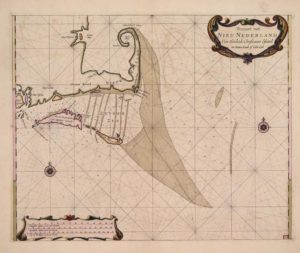
NANTUCKET – A rare first edition of a navigational map depicting Cape Cod and the Islands from Dutch cartographer Arent Roggeveen has been acquired by the Nantucket Historical Association.
The map, created in 1675, was a gift from the Friends of the NHA. It shows the area surrounding the Cape and Islands, ranging from Rhode Island up to Plymouth.
The chart was on display at the New Bedford Whaling Museum in the past.
The map is in prime condition, considering its age. It is around 100 years older than the next oldest navigational map in the NHA’s collection.
The NHA, who looks to preserve and interpret the island’s history and significance, expressed gratitude for the gift.


