 HYANNIS – Blizzard warnings have been posted for much of coastal Massachusetts, including Cape Cod, as a powerful Nor’easter makes its way up the East Coast.
Thursday’s forecast calls for coastal flooding concerns and wind gusts up to 70 mph.
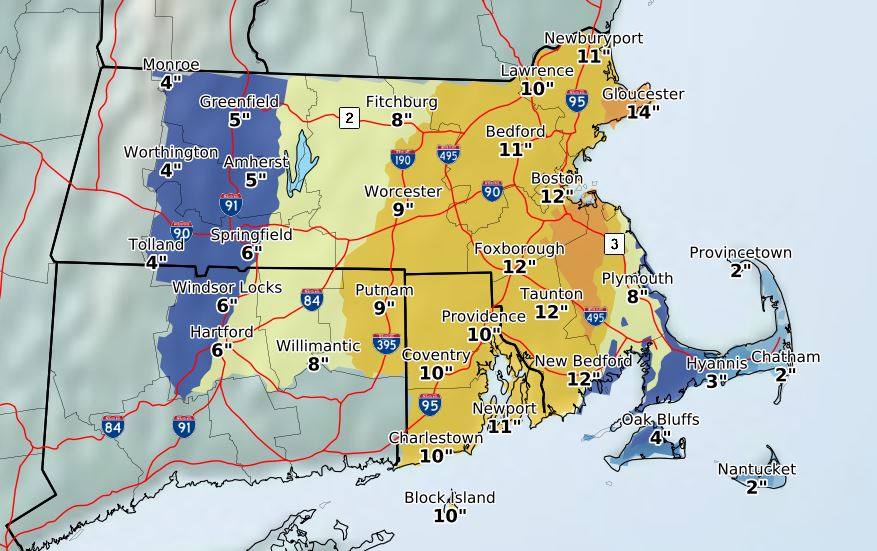
Rain will mix with snow to keep accumulations down on Cape Cod, 1-3 inches for the Mid and Lower Cape with higher amounts possible on the Upper Cape.
Parts of the South Shore and Metro Boston could see 8-12 inches of snow.
The Massachusetts Emergency Management Agency said snow will overspread the region starting early Thursday morning between 4 a.m. and 8 a.m. and last through the day before ending sometime Thursday evening.
Snowfall rates could be as much as 1-2 inches per hour.
According to the Barnstable County Regional Emergency Planning Committee, coastal flooding is a concern on the Bay side of Cape Cod during the 1 p.m. high tide on Thursday.
Electric utility Eversource will prestage tree, pole, and line crews on the Cape ahead of the storm.
The BCREPC advises the citizens of Barnstable County to be prepared for winter weather conditions and refrain from driving during the storm to enable highway crews to treat and clear the roads and utility crews to restore power as needed.
A decision about the status of the Barnstable County Regional Shelter System will be made later on Wednesday, January 3, 2018.
On the Cape and Islands, precipitation may start as rain but will transition to snow by Thursday afternoon as temperatures drop.
A flash freeze is possible in the area.
The precise location of the rain/snow line is still uncertain, but will likely will fall somewhere south of the Boston to Providence line, and north of the Cape Cod Canal.
There likely will be an area of heavy wet snow just to the north of the rain/snow line. The potential for power outages is higher in areas that receive heavy wet snow.
Wind gusts will increase Thursday morning and last into the evening.
There is concern that this storm could result in widespread power outages across the region.
Eversource is expecting tree-related damage to the electric system and says they have crews ready to respond. The company is advising customers to be prepared for outages, especially with extremely cold temperatures forecast for tonight.
National Grid, which provides power to Nantucket, says they have called in extra line crews ahead of the storm.
Interior Massachusetts could see 40-50 mph, with 50-65 mph gusts near the coast and up to 70 mph gusts on the Cape and Islands.
Bitterly cold weather will return Friday and Saturday. Daytime highs will hover around 0 degrees, while overnight lows could reach 10-20 degrees below zero.
Wind chills could be as low as 15-35 degrees below zero, particularly on Friday night when wind gusts are expected to be 35-40 mph over much of Massachusetts.
Snowfall combined with strong winds will result in poor visibility and difficult travel conditions throughout Massachusetts on Thursday.
Both morning and evening commutes are forecast to be impacted. Near-blizzard conditions are possible in eastern Massachusetts and travel in that area could become difficult to impossible.
A flash freeze is possible Thursday afternoon or evening to the south of the rain/snow line as rain transitions to snow in southeastern Massachusetts, resulting in icy conditions on roads and sidewalks.