 CHATHAM – When Owen Nichols and Charlie Beggs set out to study lobster settlement in Pleasant Bay, in 2014, both had already been working on the water for a long time so weren’t easily surprised. But that day they were – twice.
First, they found lots and lots of lobsters under a year old, as many or more than in some areas in Maine, where lobsters are supposed to be most fertile.
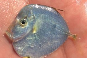
And they spotted several tropical fish around the size of a quarter, seeking refuge in their larval collectors. These colorful fish included snowy grouper and spotfin butterflyfish, fish that are much more common in the Caribbean but that presumably get carried north along the warm Gulf Stream current as larvae or very small juveniles, remaining in bays and estuaries until fall water temperatures become too cold.
Owen (director of Marine Fisheries Research Program at the Center for Coastal Studies in Provincetown), and Charlie (one of many community partners Owen relies on heavily), quantified and passed their information along.
The phenomenon of finding tropical fish locally is now being studied by University of Massachusetts graduate student Mike O’Neill, who has dubbed these fish, “Gulf Stream Orphans.”
As for the abundance of young lobsters, it’s possible that we underestimate the importance of our coastal systems, such as Pleasant Bay and Nauset Marsh (where juvenile lobsters hide in the marsh peat), as nursery habitat for this important species.
Right about the same time, 2014, the Center for Coastal Studies was starting a major project that has continued to this day: creating benthic habitat maps in many places on the Cape, one of the first being around where Owen and Charlie were working in Pleasant Bay.
These maps are just what they sound like, detailing the seafloor where the benthos (also known as little critters) live. In Pleasant Bay we went one step further and tied what lives on the seafloor to what swims in the water column, creating more of an ecosystem-wide assessment. We wanted to see how tight the connections are between what swims in water to what lives on the bottom.
Benthic invertebrates live on or just under the seafloor’s surface. They are one of the foundations of the complex food web that is a coastal ecosystem. By the way we say “food web” rather than “food chain” because these natural systems are much more complex than single links making up a chain. They are more like a spider’s web, touch one part of it and you can feel the effects elsewhere.
There are no Gulf Stream Orphans in the benthic invertebrate world. If we find them, they’re not visiting or lost. We find them there because they live here.
In search of them, we crisscross an area in a fairly tight grid, sending our research vessel along those lines, taking hundreds of bottom grab samples. Then we count and identify these little creatures that are about the size of a grain of sand.
We do this because we want to map benthic habitats so we can understand in a rigorous, repeatable, scientific way what lives here and what kind of shape each area is in. Is it healthy and thriving? Is there enough oxygen in the water? Too many nutrients?
We have completed or are completing maps in Pleasant Bay, Nauset Marsh, Wellfleet Harbor, Herring Cove Beach in Provincetown, East Harbor (Pilgrim Lake) and Barnstable Harbor. The important thing to remember is these maps are the first of their kind. We’ve collected and identified over 100,000 individuals and these maps will be used for things we haven’t even imagined yet. Gone are the anecdotal stories of what this area ‘used to be like’ or squaring what different folks said about the same bay. We think these baseline datasets should be completed for all of our coastal estuaries and lagoons.
These assessments, in fact all maps, are snapshots in time. These snapshots are critically important to tell a story we can’t know otherwise, to understand what our shoreline was like and how it is changing. The famous “In Cod We Trust” picture of a little kid standing next to a huge cod is another kind of snapshot, of a very different time and fishery. If we get enough snapshots of our ecosystem, with benthic habitat maps as the foundation, we can tell a story of an evolving coast including critters and fish, ecosystems and fisheries, orphans and families.
Repeating these snapshots is our way to begin to understand the effects of environmental and human-induced changes on marine habitats. And with that knowledge, we hope to help drive sound, smart public policy aimed at all the amazing life our habitat supports, including our historic fishing communities.
Mark Borrelli is the Director of the Seafloor Mapping Program at the Center for Coastal Studies.